You are here: Home > Network List > IU - Global Seismograph Network (GSN - IRIS/USGS) Stations List
> Station PMG Port Moresby, New Guinea > Earthquake Result Viewer
PMG Port Moresby, New Guinea - Earthquake Result Viewer
*The percent match for this event was below the threshold and hence no stack was calculated.
| Earthquake location: |
Tonga Islands |
| Earthquake latitude/longitude: |
-20.4/-173.5 |
| Earthquake time(UTC): |
2017/07/16 (197) 17:06:41 GMT |
| Earthquake Depth: |
10 km |
| Earthquake Magnitude: |
5.5 Mww |
| Earthquake Catalog/Contributor: |
NEIC PDE/us |
|
| Network: |
IU Global Seismograph Network (GSN - IRIS/USGS) |
| Station: |
PMG Port Moresby, New Guinea |
| Lat/Lon: |
9.40 S/147.16 E |
| Elevation: |
90 m |
|
| Distance: |
39.5 deg |
| Az: |
280.187 deg |
| Baz: |
110.703 deg |
| Ray Param: |
$rayparam |
*The percent match for this event was below the threshold and hence was not used in the summary stack. |
|
| Radial Match: |
62.20028 % |
| Radial Bump: |
400 |
| Transverse Match: |
67.21309 % |
| Transverse Bump: |
400 |
| SOD ConfigId: |
2140511 |
| Insert Time: |
2017-07-30 09:04:32.098 +0000 |
| GWidth: |
2.5 |
| Max Bumps: |
400 |
| Tol: |
0.001 |
|
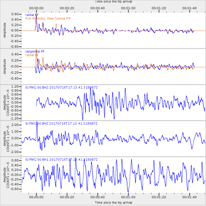
Signal To Noise
| Channel | StoN | STA | LTA |
| IU:PMG:00:BHZ:20170716T17:13:41.318987Z | 4.1462774 | 9.651714E-7 | 2.3278021E-7 |
| IU:PMG:00:BH1:20170716T17:13:41.318987Z | 1.287539 | 2.823633E-7 | 2.1930465E-7 |
| IU:PMG:00:BH2:20170716T17:13:41.318987Z | 3.0696309 | 5.4923373E-7 | 1.7892502E-7 |
| Arrivals |
| Ps | |
| PpPs | |
| PsPs/PpSs | |


