You are here: Home > Network List > CN - Canadian National Seismograph Network Stations List
> Station KGNO KINGSTON, ON > Earthquake Result Viewer
KGNO KINGSTON, ON - Earthquake Result Viewer
| Earthquake location: |
Alaska Peninsula |
| Earthquake latitude/longitude: |
54.8/-161.2 |
| Earthquake time(UTC): |
2020/07/28 (210) 08:03:44 GMT |
| Earthquake Depth: |
60 km |
| Earthquake Magnitude: |
5.9 Mi |
| Earthquake Catalog/Contributor: |
NEIC PDE/at |
|
| Network: |
CN Canadian National Seismograph Network |
| Station: |
KGNO KINGSTON, ON |
| Lat/Lon: |
44.23 N/76.49 W |
| Elevation: |
89 m |
|
| Distance: |
52.8 deg |
| Az: |
64.057 deg |
| Baz: |
313.562 deg |
| Ray Param: |
0.06640459 |
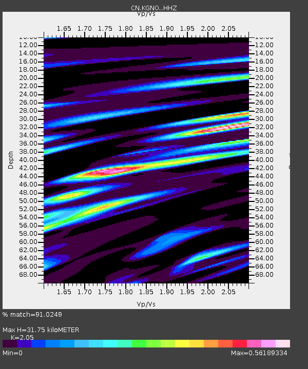
| Estimated Moho Depth: |
31.75 km |
| Estimated Crust Vp/Vs: |
2.05 |
| Assumed Crust Vp: |
6.577 km/s |
| Estimated Crust Vs: |
3.208 km/s |
| Estimated Crust Poisson's Ratio: |
0.34 |
|
| Radial Match: |
91.0249 % |
| Radial Bump: |
299 |
| Transverse Match: |
66.8358 % |
| Transverse Bump: |
400 |
| SOD ConfigId: |
21709731 |
| Insert Time: |
2020-08-11 08:08:55.636 +0000 |
| GWidth: |
2.5 |
| Max Bumps: |
400 |
| Tol: |
0.001 |
|

Signal To Noise
| Channel | StoN | STA | LTA |
| CN:KGNO: :HHZ:20200728T08:12:22.23999Z | 6.0233746 | 7.979883E-7 | 1.3248193E-7 |
| CN:KGNO: :HHN:20200728T08:12:22.23999Z | 5.3955197 | 3.5325382E-7 | 6.5471696E-8 |
| CN:KGNO: :HHE:20200728T08:12:22.23999Z | 4.799464 | 3.0068347E-7 | 6.264938E-8 |
| Arrivals |
| Ps | 5.3 SECOND |
| PpPs | 14 SECOND |
| PsPs/PpSs | 19 SECOND |


