You are here: Home > Network List > CN - Canadian National Seismograph Network Stations List
> Station SUBO Sudbury, ON, CA > Earthquake Result Viewer
SUBO Sudbury, ON, CA - Earthquake Result Viewer
| Earthquake location: |
Alaska Peninsula |
| Earthquake latitude/longitude: |
54.8/-161.2 |
| Earthquake time(UTC): |
2020/07/28 (210) 08:03:44 GMT |
| Earthquake Depth: |
60 km |
| Earthquake Magnitude: |
5.9 Mi |
| Earthquake Catalog/Contributor: |
NEIC PDE/at |
|
| Network: |
CN Canadian National Seismograph Network |
| Station: |
SUBO Sudbury, ON, CA |
| Lat/Lon: |
46.61 N/81.13 W |
| Elevation: |
281 m |
|
| Distance: |
48.7 deg |
| Az: |
64.601 deg |
| Baz: |
310.611 deg |
| Ray Param: |
0.06899742 |
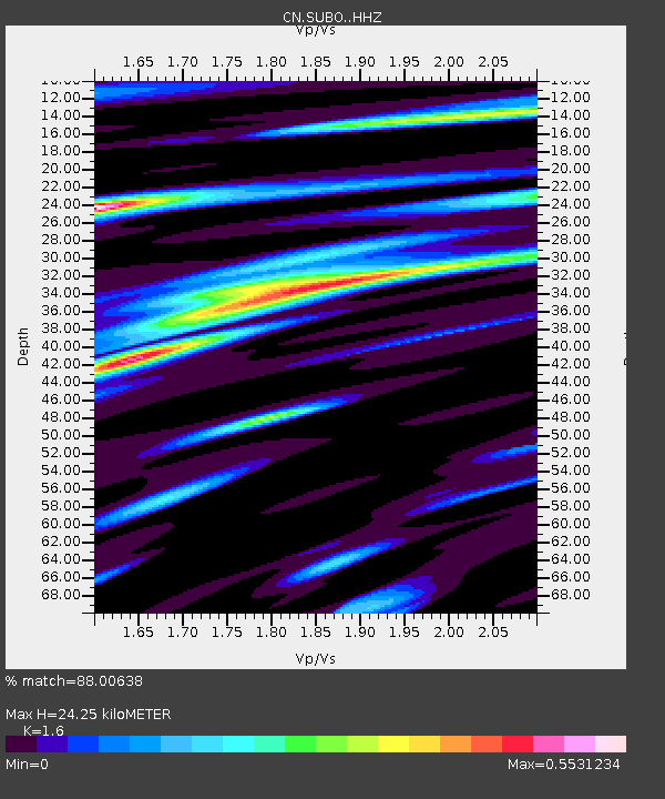
| Estimated Moho Depth: |
24.25 km |
| Estimated Crust Vp/Vs: |
1.60 |
| Assumed Crust Vp: |
6.467 km/s |
| Estimated Crust Vs: |
4.042 km/s |
| Estimated Crust Poisson's Ratio: |
0.18 |
|
| Radial Match: |
88.00638 % |
| Radial Bump: |
332 |
| Transverse Match: |
72.42824 % |
| Transverse Bump: |
400 |
| SOD ConfigId: |
21709731 |
| Insert Time: |
2020-08-11 08:09:25.999 +0000 |
| GWidth: |
2.5 |
| Max Bumps: |
400 |
| Tol: |
0.001 |
|

Signal To Noise
| Channel | StoN | STA | LTA |
| CN:SUBO: :HHZ:20200728T08:11:52.049988Z | 9.744819 | 9.3604274E-7 | 9.605543E-8 |
| CN:SUBO: :HHN:20200728T08:11:52.049988Z | 3.7724967 | 2.2839625E-7 | 6.054246E-8 |
| CN:SUBO: :HHE:20200728T08:11:52.049988Z | 3.6252346 | 2.570982E-7 | 7.091906E-8 |
| Arrivals |
| Ps | 2.4 SECOND |
| PpPs | 9.1 SECOND |
| PsPs/PpSs | 12 SECOND |


