You are here: Home > Network List > ET - CERI Southern Appalachian seismic Network Stations List
> Station SWET Sewanee,TN > Earthquake Result Viewer
SWET Sewanee,TN - Earthquake Result Viewer
| Earthquake location: |
Alaska Peninsula |
| Earthquake latitude/longitude: |
54.8/-161.2 |
| Earthquake time(UTC): |
2020/07/28 (210) 08:03:44 GMT |
| Earthquake Depth: |
60 km |
| Earthquake Magnitude: |
5.9 Mi |
| Earthquake Catalog/Contributor: |
NEIC PDE/at |
|
| Network: |
ET CERI Southern Appalachian seismic Network |
| Station: |
SWET Sewanee,TN |
| Lat/Lon: |
35.22 N/85.93 W |
| Elevation: |
581 m |
|
| Distance: |
53.9 deg |
| Az: |
78.406 deg |
| Baz: |
316.124 deg |
| Ray Param: |
0.065628245 |
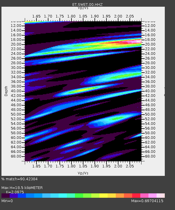
| Estimated Moho Depth: |
18.5 km |
| Estimated Crust Vp/Vs: |
2.10 |
| Assumed Crust Vp: |
6.35 km/s |
| Estimated Crust Vs: |
3.027 km/s |
| Estimated Crust Poisson's Ratio: |
0.35 |
|
| Radial Match: |
90.42384 % |
| Radial Bump: |
400 |
| Transverse Match: |
82.269196 % |
| Transverse Bump: |
400 |
| SOD ConfigId: |
21709731 |
| Insert Time: |
2020-08-11 08:10:42.956 +0000 |
| GWidth: |
2.5 |
| Max Bumps: |
400 |
| Tol: |
0.001 |
|

Signal To Noise
| Channel | StoN | STA | LTA |
| ET:SWET:00:HHZ:20200728T08:12:30.820007Z | 7.9949865 | 5.8010164E-7 | 7.255818E-8 |
| ET:SWET:00:HHN:20200728T08:12:30.820007Z | 4.863255 | 1.8823278E-7 | 3.87051E-8 |
| ET:SWET:00:HHE:20200728T08:12:30.820007Z | 2.8097148 | 1.4479602E-7 | 5.1534062E-8 |
| Arrivals |
| Ps | 3.3 SECOND |
| PpPs | 8.6 SECOND |
| PsPs/PpSs | 12 SECOND |


