You are here: Home > Network List > G - GEOSCOPE Stations List
> Station IVI Ivittuut, Greenland > Earthquake Result Viewer
IVI Ivittuut, Greenland - Earthquake Result Viewer
| Earthquake location: |
Alaska Peninsula |
| Earthquake latitude/longitude: |
54.8/-161.2 |
| Earthquake time(UTC): |
2020/07/28 (210) 08:03:44 GMT |
| Earthquake Depth: |
60 km |
| Earthquake Magnitude: |
5.9 Mi |
| Earthquake Catalog/Contributor: |
NEIC PDE/at |
|
| Network: |
G GEOSCOPE |
| Station: |
IVI Ivittuut, Greenland |
| Lat/Lon: |
61.21 N/48.17 W |
| Elevation: |
15 m |
|
| Distance: |
52.9 deg |
| Az: |
33.989 deg |
| Baz: |
318.015 deg |
| Ray Param: |
0.06632859 |
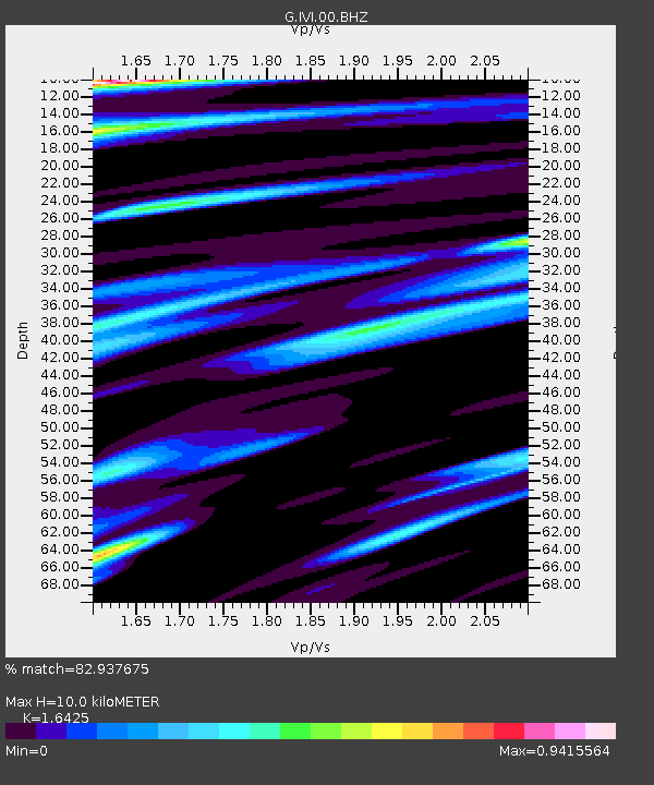
| Estimated Moho Depth: |
10.0 km |
| Estimated Crust Vp/Vs: |
1.64 |
| Assumed Crust Vp: |
6.472 km/s |
| Estimated Crust Vs: |
3.94 km/s |
| Estimated Crust Poisson's Ratio: |
0.21 |
|
| Radial Match: |
82.937675 % |
| Radial Bump: |
400 |
| Transverse Match: |
64.50868 % |
| Transverse Bump: |
394 |
| SOD ConfigId: |
21709731 |
| Insert Time: |
2020-08-11 08:10:50.965 +0000 |
| GWidth: |
2.5 |
| Max Bumps: |
400 |
| Tol: |
0.001 |
|
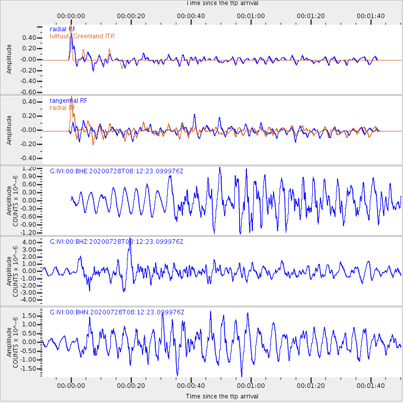
Signal To Noise
| Channel | StoN | STA | LTA |
| G:IVI:00:BHZ:20200728T08:12:23.099976Z | 3.5513043 | 8.824981E-7 | 2.4849973E-7 |
| G:IVI:00:BHN:20200728T08:12:23.099976Z | 1.1480851 | 3.5798044E-7 | 3.1180653E-7 |
| G:IVI:00:BHE:20200728T08:12:23.099976Z | 1.6864897 | 4.846639E-7 | 2.873803E-7 |
| Arrivals |
| Ps | 1.1 SECOND |
| PpPs | 3.8 SECOND |
| PsPs/PpSs | 4.9 SECOND |


