You are here: Home > Network List > GS - US Geological Survey Networks Stations List
> Station DEC13 Justin Breden Machine Shed, Decatur, IL, USA > Earthquake Result Viewer
DEC13 Justin Breden Machine Shed, Decatur, IL, USA - Earthquake Result Viewer
| Earthquake location: |
Alaska Peninsula |
| Earthquake latitude/longitude: |
54.8/-161.2 |
| Earthquake time(UTC): |
2020/07/28 (210) 08:03:44 GMT |
| Earthquake Depth: |
60 km |
| Earthquake Magnitude: |
5.9 Mi |
| Earthquake Catalog/Contributor: |
NEIC PDE/at |
|
| Network: |
GS US Geological Survey Networks |
| Station: |
DEC13 Justin Breden Machine Shed, Decatur, IL, USA |
| Lat/Lon: |
39.90 N/88.88 W |
| Elevation: |
224 m |
|
| Distance: |
49.0 deg |
| Az: |
76.248 deg |
| Baz: |
312.987 deg |
| Ray Param: |
0.06883312 |
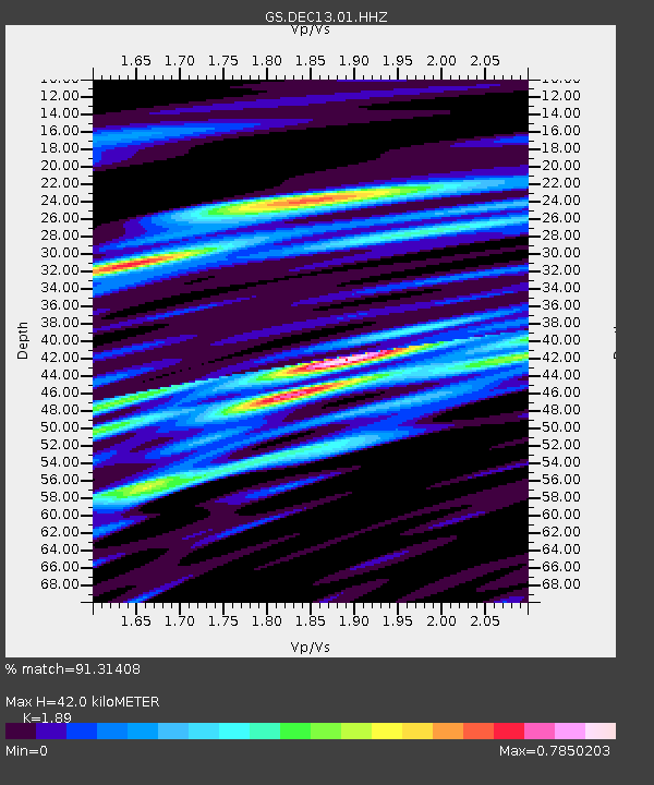
| Estimated Moho Depth: |
42.0 km |
| Estimated Crust Vp/Vs: |
1.89 |
| Assumed Crust Vp: |
6.444 km/s |
| Estimated Crust Vs: |
3.409 km/s |
| Estimated Crust Poisson's Ratio: |
0.31 |
|
| Radial Match: |
91.31408 % |
| Radial Bump: |
400 |
| Transverse Match: |
78.14386 % |
| Transverse Bump: |
400 |
| SOD ConfigId: |
21709731 |
| Insert Time: |
2020-08-11 08:12:15.951 +0000 |
| GWidth: |
2.5 |
| Max Bumps: |
400 |
| Tol: |
0.001 |
|

Signal To Noise
| Channel | StoN | STA | LTA |
| GS:DEC13:01:HHZ:20200728T08:11:53.904999Z | 10.890799 | 1.4689166E-6 | 1.3487684E-7 |
| GS:DEC13:01:HHN:20200728T08:11:53.904999Z | 1.9943917 | 5.452683E-7 | 2.7340081E-7 |
| GS:DEC13:01:HHE:20200728T08:11:53.904999Z | 2.0525925 | 7.157339E-7 | 3.4869748E-7 |
| Arrivals |
| Ps | 6.1 SECOND |
| PpPs | 18 SECOND |
| PsPs/PpSs | 24 SECOND |


