You are here: Home > Network List > IE - INL Seismic Monitoring Program Stations List
> Station BCYI Bear Canyon, Idaho, USA > Earthquake Result Viewer
BCYI Bear Canyon, Idaho, USA - Earthquake Result Viewer
| Earthquake location: |
Alaska Peninsula |
| Earthquake latitude/longitude: |
54.8/-161.2 |
| Earthquake time(UTC): |
2020/07/28 (210) 08:03:44 GMT |
| Earthquake Depth: |
60 km |
| Earthquake Magnitude: |
5.9 Mi |
| Earthquake Catalog/Contributor: |
NEIC PDE/at |
|
| Network: |
IE INL Seismic Monitoring Program |
| Station: |
BCYI Bear Canyon, Idaho, USA |
| Lat/Lon: |
44.31 N/113.41 W |
| Elevation: |
2194 m |
|
| Distance: |
32.1 deg |
| Az: |
88.932 deg |
| Baz: |
306.212 deg |
| Ray Param: |
0.0786713 |
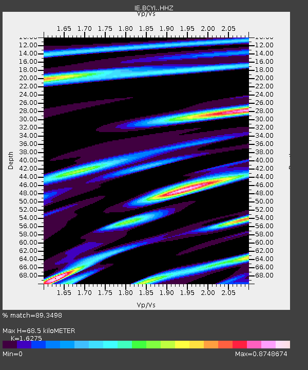
| Estimated Moho Depth: |
68.5 km |
| Estimated Crust Vp/Vs: |
1.63 |
| Assumed Crust Vp: |
6.577 km/s |
| Estimated Crust Vs: |
4.041 km/s |
| Estimated Crust Poisson's Ratio: |
0.20 |
|
| Radial Match: |
89.3498 % |
| Radial Bump: |
400 |
| Transverse Match: |
89.418045 % |
| Transverse Bump: |
400 |
| SOD ConfigId: |
21709731 |
| Insert Time: |
2020-08-11 08:13:14.950 +0000 |
| GWidth: |
2.5 |
| Max Bumps: |
400 |
| Tol: |
0.001 |
|

Signal To Noise
| Channel | StoN | STA | LTA |
| IE:BCYI: :HHZ:20200728T08:09:35.269989Z | 4.60924 | 2.6259468E-7 | 5.697136E-8 |
| IE:BCYI: :HHN:20200728T08:09:35.269989Z | 2.4405148 | 1.1481242E-7 | 4.704435E-8 |
| IE:BCYI: :HHE:20200728T08:09:35.269989Z | 3.0433185 | 1.2439288E-7 | 4.0874095E-8 |
| Arrivals |
| Ps | 7.2 SECOND |
| PpPs | 25 SECOND |
| PsPs/PpSs | 32 SECOND |


