You are here: Home > Network List > IM - International Miscellaneous Stations Stations List
> Station TKL Tuckaleechee Caverns, TN, USA > Earthquake Result Viewer
TKL Tuckaleechee Caverns, TN, USA - Earthquake Result Viewer
| Earthquake location: |
Alaska Peninsula |
| Earthquake latitude/longitude: |
54.8/-161.2 |
| Earthquake time(UTC): |
2020/07/28 (210) 08:03:44 GMT |
| Earthquake Depth: |
60 km |
| Earthquake Magnitude: |
5.9 Mi |
| Earthquake Catalog/Contributor: |
NEIC PDE/at |
|
| Network: |
IM International Miscellaneous Stations |
| Station: |
TKL Tuckaleechee Caverns, TN, USA |
| Lat/Lon: |
35.66 N/83.77 W |
| Elevation: |
351 m |
|
| Distance: |
54.8 deg |
| Az: |
76.466 deg |
| Baz: |
316.24 deg |
| Ray Param: |
0.065043665 |
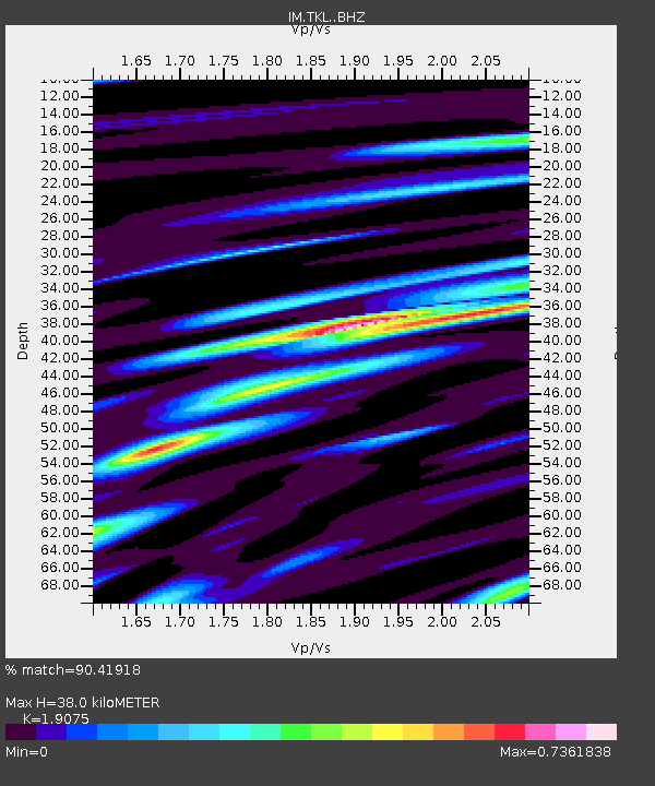
| Estimated Moho Depth: |
38.0 km |
| Estimated Crust Vp/Vs: |
1.91 |
| Assumed Crust Vp: |
6.35 km/s |
| Estimated Crust Vs: |
3.329 km/s |
| Estimated Crust Poisson's Ratio: |
0.31 |
|
| Radial Match: |
90.41918 % |
| Radial Bump: |
400 |
| Transverse Match: |
81.533775 % |
| Transverse Bump: |
400 |
| SOD ConfigId: |
21709731 |
| Insert Time: |
2020-08-11 08:13:40.184 +0000 |
| GWidth: |
2.5 |
| Max Bumps: |
400 |
| Tol: |
0.001 |
|

Signal To Noise
| Channel | StoN | STA | LTA |
| IM:TKL: :BHZ:20200728T08:12:37.369019Z | 7.6908956 | 4.928911E-7 | 6.408761E-8 |
| IM:TKL: :BHN:20200728T08:12:37.369019Z | 6.858614 | 2.1228222E-7 | 3.095118E-8 |
| IM:TKL: :BHE:20200728T08:12:37.369019Z | 4.2291284 | 1.7184388E-7 | 4.0633406E-8 |
| Arrivals |
| Ps | 5.7 SECOND |
| PpPs | 17 SECOND |
| PsPs/PpSs | 22 SECOND |


