You are here: Home > Network List > US - United States National Seismic Network Stations List
> Station MNTX Cornudas Mountains, Texas, USA > Earthquake Result Viewer
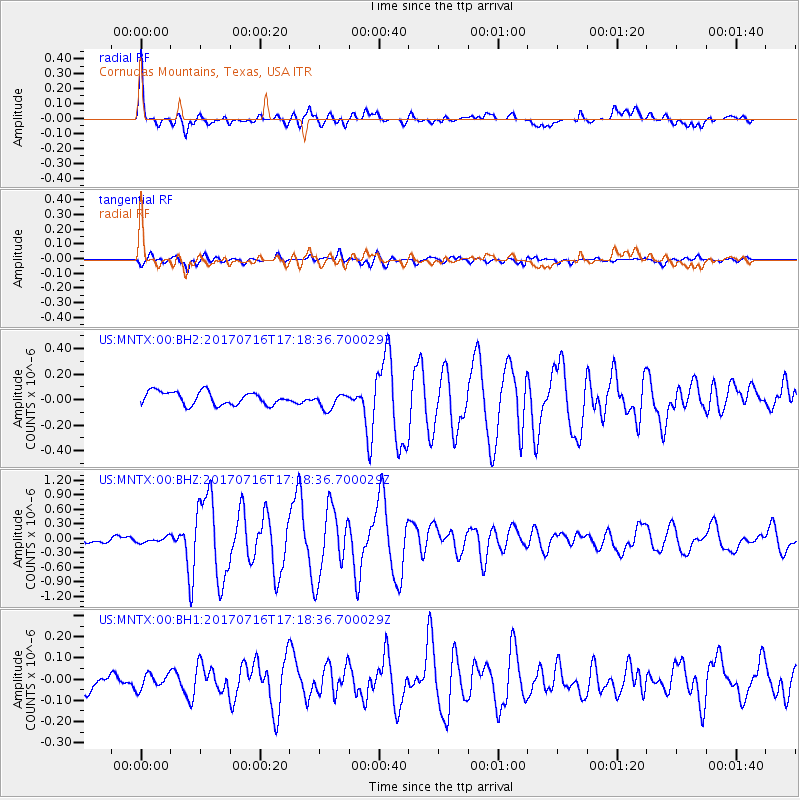
MNTX Cornudas Mountains, Texas, USA - Earthquake Result Viewer
*The percent match for this event was below the threshold and hence no stack was calculated.
| Earthquake location: |
Tonga Islands |
| Earthquake latitude/longitude: |
-20.4/-173.5 |
| Earthquake time(UTC): |
2017/07/16 (197) 17:06:41 GMT |
| Earthquake Depth: |
10 km |
| Earthquake Magnitude: |
5.5 Mww |
| Earthquake Catalog/Contributor: |
NEIC PDE/us |
|
| Network: |
US United States National Seismic Network |
| Station: |
MNTX Cornudas Mountains, Texas, USA |
| Lat/Lon: |
31.70 N/105.38 W |
| Elevation: |
404 m |
|
| Distance: |
83.3 deg |
| Az: |
52.768 deg |
| Baz: |
241.159 deg |
| Ray Param: |
$rayparam |
*The percent match for this event was below the threshold and hence was not used in the summary stack. |
|
| Radial Match: |
77.947136 % |
| Radial Bump: |
400 |
| Transverse Match: |
79.74521 % |
| Transverse Bump: |
400 |
| SOD ConfigId: |
2140511 |
| Insert Time: |
2017-07-30 09:06:23.923 +0000 |
| GWidth: |
2.5 |
| Max Bumps: |
400 |
| Tol: |
0.001 |
|
Signal To Noise
| Channel | StoN | STA | LTA |
| US:MNTX:00:BHZ:20170716T17:18:36.700029Z | 0.9565225 | 5.7590025E-8 | 6.0207704E-8 |
| US:MNTX:00:BH1:20170716T17:18:36.700029Z | 0.79434305 | 3.4760898E-8 | 4.376056E-8 |
| US:MNTX:00:BH2:20170716T17:18:36.700029Z | 1.1979524 | 6.1438016E-8 | 5.1285856E-8 |
| Arrivals |
| Ps | |
| PpPs | |
| PsPs/PpSs | |


