You are here: Home > Network List > MG - Seismic Network of the NorthEastern Mexico Stations List
> Station TXMV CEIEPAA, FMVZ, UNAM, Tequisquiapan, Queretaro, MEXICO > Earthquake Result Viewer
TXMV CEIEPAA, FMVZ, UNAM, Tequisquiapan, Queretaro, MEXICO - Earthquake Result Viewer
| Earthquake location: |
Alaska Peninsula |
| Earthquake latitude/longitude: |
54.8/-161.2 |
| Earthquake time(UTC): |
2020/07/28 (210) 08:03:44 GMT |
| Earthquake Depth: |
60 km |
| Earthquake Magnitude: |
5.9 Mi |
| Earthquake Catalog/Contributor: |
NEIC PDE/at |
|
| Network: |
MG Seismic Network of the NorthEastern Mexico |
| Station: |
TXMV CEIEPAA, FMVZ, UNAM, Tequisquiapan, Queretaro, MEXICO |
| Lat/Lon: |
20.61 N/99.93 W |
| Elevation: |
1908 m |
|
| Distance: |
56.9 deg |
| Az: |
101.344 deg |
| Baz: |
322.674 deg |
| Ray Param: |
0.06369255 |
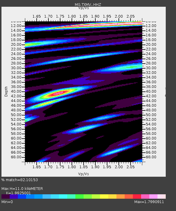
| Estimated Moho Depth: |
11.0 km |
| Estimated Crust Vp/Vs: |
1.99 |
| Assumed Crust Vp: |
6.466 km/s |
| Estimated Crust Vs: |
3.245 km/s |
| Estimated Crust Poisson's Ratio: |
0.33 |
|
| Radial Match: |
82.10153 % |
| Radial Bump: |
400 |
| Transverse Match: |
83.86086 % |
| Transverse Bump: |
400 |
| SOD ConfigId: |
21709731 |
| Insert Time: |
2020-08-11 08:16:16.431 +0000 |
| GWidth: |
2.5 |
| Max Bumps: |
400 |
| Tol: |
0.001 |
|

Signal To Noise
| Channel | StoN | STA | LTA |
| MG:TXMV: :HHZ:20200728T08:12:51.989014Z | 4.012813 | 7.622988E-8 | 1.899662E-8 |
| MG:TXMV: :HHN:20200728T08:12:51.989014Z | 1.7894527 | 5.372176E-8 | 3.0021333E-8 |
| MG:TXMV: :HHE:20200728T08:12:51.989014Z | 0.85300124 | 2.2753225E-8 | 2.6674316E-8 |
| Arrivals |
| Ps | 1.8 SECOND |
| PpPs | 4.9 SECOND |
| PsPs/PpSs | 6.6 SECOND |


