You are here: Home > Network List > N4 - Central and EAstern US Network Stations List
> Station 152A Waverly Hall, GA, USA > Earthquake Result Viewer
152A Waverly Hall, GA, USA - Earthquake Result Viewer
| Earthquake location: |
Alaska Peninsula |
| Earthquake latitude/longitude: |
54.8/-161.2 |
| Earthquake time(UTC): |
2020/07/28 (210) 08:03:44 GMT |
| Earthquake Depth: |
60 km |
| Earthquake Magnitude: |
5.9 Mi |
| Earthquake Catalog/Contributor: |
NEIC PDE/at |
|
| Network: |
N4 Central and EAstern US Network |
| Station: |
152A Waverly Hall, GA, USA |
| Lat/Lon: |
32.67 N/84.72 W |
| Elevation: |
214 m |
|
| Distance: |
56.5 deg |
| Az: |
79.628 deg |
| Baz: |
317.496 deg |
| Ray Param: |
0.063971326 |
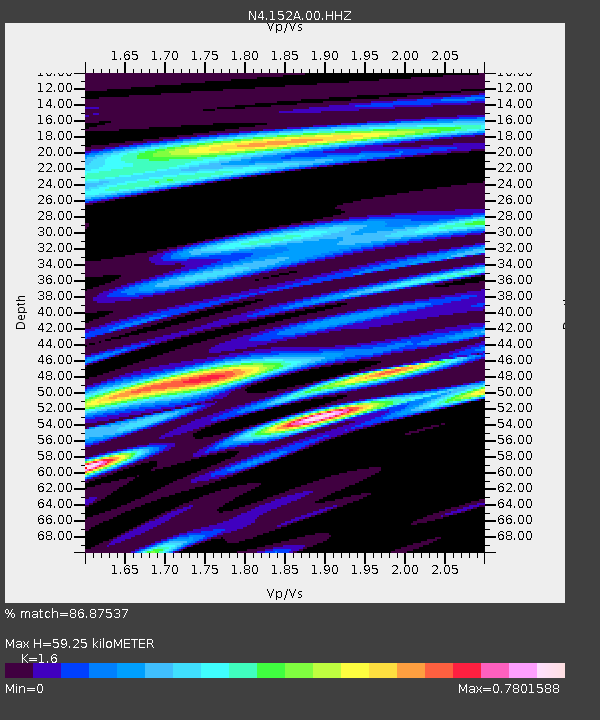
| Estimated Moho Depth: |
59.25 km |
| Estimated Crust Vp/Vs: |
1.60 |
| Assumed Crust Vp: |
6.719 km/s |
| Estimated Crust Vs: |
4.2 km/s |
| Estimated Crust Poisson's Ratio: |
0.18 |
|
| Radial Match: |
86.87537 % |
| Radial Bump: |
400 |
| Transverse Match: |
58.98369 % |
| Transverse Bump: |
400 |
| SOD ConfigId: |
21709731 |
| Insert Time: |
2020-08-11 08:16:51.030 +0000 |
| GWidth: |
2.5 |
| Max Bumps: |
400 |
| Tol: |
0.001 |
|

Signal To Noise
| Channel | StoN | STA | LTA |
| N4:152A:00:HHZ:20200728T08:12:49.090027Z | 7.124519 | 3.7878115E-7 | 5.316586E-8 |
| N4:152A:00:HH1:20200728T08:12:49.090027Z | 2.478283 | 1.2729878E-7 | 5.1365717E-8 |
| N4:152A:00:HH2:20200728T08:12:49.090027Z | 2.5260563 | 1.2686888E-7 | 5.022409E-8 |
| Arrivals |
| Ps | 5.6 SECOND |
| PpPs | 22 SECOND |
| PsPs/PpSs | 27 SECOND |


