You are here: Home > Network List > N4 - Central and EAstern US Network Stations List
> Station H43A Windswept, Luxemburg, WI, USA > Earthquake Result Viewer
H43A Windswept, Luxemburg, WI, USA - Earthquake Result Viewer
| Earthquake location: |
Alaska Peninsula |
| Earthquake latitude/longitude: |
54.8/-161.2 |
| Earthquake time(UTC): |
2020/07/28 (210) 08:03:44 GMT |
| Earthquake Depth: |
60 km |
| Earthquake Magnitude: |
5.9 Mi |
| Earthquake Catalog/Contributor: |
NEIC PDE/at |
|
| Network: |
N4 Central and EAstern US Network |
| Station: |
H43A Windswept, Luxemburg, WI, USA |
| Lat/Lon: |
44.47 N/87.77 W |
| Elevation: |
274 m |
|
| Distance: |
46.6 deg |
| Az: |
70.895 deg |
| Baz: |
310.129 deg |
| Ray Param: |
0.0704027 |
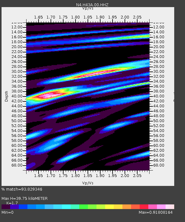
| Estimated Moho Depth: |
39.75 km |
| Estimated Crust Vp/Vs: |
1.70 |
| Assumed Crust Vp: |
6.53 km/s |
| Estimated Crust Vs: |
3.841 km/s |
| Estimated Crust Poisson's Ratio: |
0.24 |
|
| Radial Match: |
93.829346 % |
| Radial Bump: |
286 |
| Transverse Match: |
78.60102 % |
| Transverse Bump: |
400 |
| SOD ConfigId: |
21709731 |
| Insert Time: |
2020-08-11 08:17:23.769 +0000 |
| GWidth: |
2.5 |
| Max Bumps: |
400 |
| Tol: |
0.001 |
|

Signal To Noise
| Channel | StoN | STA | LTA |
| N4:H43A:00:HHZ:20200728T08:11:35.26001Z | 14.45029 | 9.909613E-7 | 6.8577265E-8 |
| N4:H43A:00:HH1:20200728T08:11:35.26001Z | 8.671027 | 3.3761768E-7 | 3.89363E-8 |
| N4:H43A:00:HH2:20200728T08:11:35.26001Z | 7.5320363 | 3.582531E-7 | 4.756391E-8 |
| Arrivals |
| Ps | 4.6 SECOND |
| PpPs | 15 SECOND |
| PsPs/PpSs | 20 SECOND |


