You are here: Home > Network List > N4 - Central and EAstern US Network Stations List
> Station I37B Waseca, MN, USA > Earthquake Result Viewer
I37B Waseca, MN, USA - Earthquake Result Viewer
| Earthquake location: |
Alaska Peninsula |
| Earthquake latitude/longitude: |
54.8/-161.2 |
| Earthquake time(UTC): |
2020/07/28 (210) 08:03:44 GMT |
| Earthquake Depth: |
60 km |
| Earthquake Magnitude: |
5.9 Mi |
| Earthquake Catalog/Contributor: |
NEIC PDE/at |
|
| Network: |
N4 Central and EAstern US Network |
| Station: |
I37B Waseca, MN, USA |
| Lat/Lon: |
44.01 N/93.40 W |
| Elevation: |
354 m |
|
| Distance: |
43.7 deg |
| Az: |
75.029 deg |
| Baz: |
309.13 deg |
| Ray Param: |
0.07218477 |
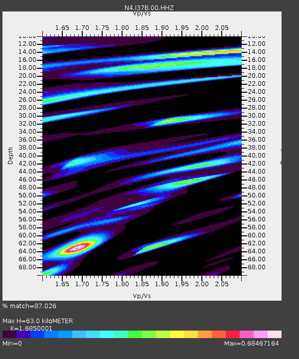
| Estimated Moho Depth: |
63.0 km |
| Estimated Crust Vp/Vs: |
1.69 |
| Assumed Crust Vp: |
6.571 km/s |
| Estimated Crust Vs: |
3.899 km/s |
| Estimated Crust Poisson's Ratio: |
0.23 |
|
| Radial Match: |
87.026 % |
| Radial Bump: |
351 |
| Transverse Match: |
78.17815 % |
| Transverse Bump: |
400 |
| SOD ConfigId: |
21709731 |
| Insert Time: |
2020-08-11 08:17:26.615 +0000 |
| GWidth: |
2.5 |
| Max Bumps: |
400 |
| Tol: |
0.001 |
|

Signal To Noise
| Channel | StoN | STA | LTA |
| N4:I37B:00:HHZ:20200728T08:11:12.889008Z | 7.396981 | 1.1887386E-6 | 1.6070591E-7 |
| N4:I37B:00:HH1:20200728T08:11:12.889008Z | 2.3634727 | 3.4708387E-7 | 1.4685334E-7 |
| N4:I37B:00:HH2:20200728T08:11:12.889008Z | 4.579861 | 4.7150223E-7 | 1.02951205E-7 |
| Arrivals |
| Ps | 7.1 SECOND |
| PpPs | 24 SECOND |
| PsPs/PpSs | 31 SECOND |


