You are here: Home > Network List > N4 - Central and EAstern US Network Stations List
> Station L56A Greenwood, NY, USA > Earthquake Result Viewer
L56A Greenwood, NY, USA - Earthquake Result Viewer
| Earthquake location: |
Alaska Peninsula |
| Earthquake latitude/longitude: |
54.8/-161.2 |
| Earthquake time(UTC): |
2020/07/28 (210) 08:03:44 GMT |
| Earthquake Depth: |
60 km |
| Earthquake Magnitude: |
5.9 Mi |
| Earthquake Catalog/Contributor: |
NEIC PDE/at |
|
| Network: |
N4 Central and EAstern US Network |
| Station: |
L56A Greenwood, NY, USA |
| Lat/Lon: |
42.14 N/77.56 W |
| Elevation: |
688 m |
|
| Distance: |
53.6 deg |
| Az: |
66.611 deg |
| Baz: |
314.365 deg |
| Ray Param: |
0.06580422 |
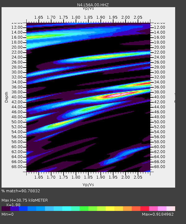
| Estimated Moho Depth: |
38.75 km |
| Estimated Crust Vp/Vs: |
1.98 |
| Assumed Crust Vp: |
6.476 km/s |
| Estimated Crust Vs: |
3.271 km/s |
| Estimated Crust Poisson's Ratio: |
0.33 |
|
| Radial Match: |
90.78832 % |
| Radial Bump: |
400 |
| Transverse Match: |
78.03873 % |
| Transverse Bump: |
400 |
| SOD ConfigId: |
21709731 |
| Insert Time: |
2020-08-11 08:17:56.751 +0000 |
| GWidth: |
2.5 |
| Max Bumps: |
400 |
| Tol: |
0.001 |
|

Signal To Noise
| Channel | StoN | STA | LTA |
| N4:L56A:00:HHZ:20200728T08:12:28.76001Z | 6.738113 | 9.1285403E-7 | 1.3547621E-7 |
| N4:L56A:00:HH1:20200728T08:12:28.76001Z | 3.7978368 | 2.7739677E-7 | 7.3040724E-8 |
| N4:L56A:00:HH2:20200728T08:12:28.76001Z | 2.4053576 | 2.907734E-7 | 1.2088572E-7 |
| Arrivals |
| Ps | 6.2 SECOND |
| PpPs | 17 SECOND |
| PsPs/PpSs | 23 SECOND |


