You are here: Home > Network List > UU - University of Utah Regional Network Stations List
> Station TMU Trail Mountain (BB), UT, USA > Earthquake Result Viewer
TMU Trail Mountain (BB), UT, USA - Earthquake Result Viewer
| Earthquake location: |
Tonga Islands |
| Earthquake latitude/longitude: |
-20.4/-173.5 |
| Earthquake time(UTC): |
2017/07/16 (197) 17:06:41 GMT |
| Earthquake Depth: |
10 km |
| Earthquake Magnitude: |
5.5 Mww |
| Earthquake Catalog/Contributor: |
NEIC PDE/us |
|
| Network: |
UU University of Utah Regional Network |
| Station: |
TMU Trail Mountain (BB), UT, USA |
| Lat/Lon: |
39.30 N/111.21 W |
| Elevation: |
2731 m |
|
| Distance: |
83.1 deg |
| Az: |
43.762 deg |
| Baz: |
236.713 deg |
| Ray Param: |
0.04641748 |
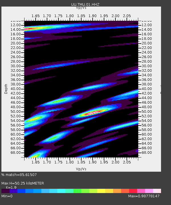
| Estimated Moho Depth: |
50.25 km |
| Estimated Crust Vp/Vs: |
1.90 |
| Assumed Crust Vp: |
6.207 km/s |
| Estimated Crust Vs: |
3.267 km/s |
| Estimated Crust Poisson's Ratio: |
0.31 |
|
| Radial Match: |
85.61507 % |
| Radial Bump: |
400 |
| Transverse Match: |
84.91169 % |
| Transverse Bump: |
400 |
| SOD ConfigId: |
2140511 |
| Insert Time: |
2017-07-30 09:07:46.829 +0000 |
| GWidth: |
2.5 |
| Max Bumps: |
400 |
| Tol: |
0.001 |
|

Signal To Noise
| Channel | StoN | STA | LTA |
| UU:TMU:01:HHZ:20170716T17:18:35.839983Z | 0.6103613 | 1.2450768E-9 | 2.0399014E-9 |
| UU:TMU:01:HHN:20170716T17:18:35.839983Z | 1.1704799 | 4.0034958E-9 | 3.4203884E-9 |
| UU:TMU:01:HHE:20170716T17:18:35.839983Z | 1.4287733 | 2.4009976E-9 | 1.6804609E-9 |
| Arrivals |
| Ps | 7.5 SECOND |
| PpPs | 23 SECOND |
| PsPs/PpSs | 30 SECOND |


