You are here: Home > Network List > N4 - Central and EAstern US Network Stations List
> Station N58A Sunbury, PA, USA > Earthquake Result Viewer
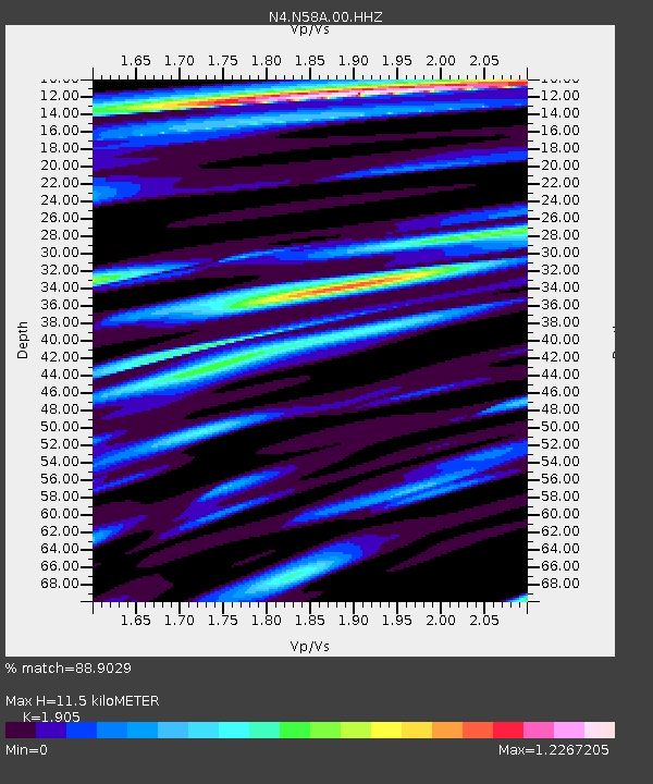
N58A Sunbury, PA, USA - Earthquake Result Viewer
| Earthquake location: |
Alaska Peninsula |
| Earthquake latitude/longitude: |
54.8/-161.2 |
| Earthquake time(UTC): |
2020/07/28 (210) 08:03:44 GMT |
| Earthquake Depth: |
60 km |
| Earthquake Magnitude: |
5.9 Mi |
| Earthquake Catalog/Contributor: |
NEIC PDE/at |
|
| Network: |
N4 Central and EAstern US Network |
| Station: |
N58A Sunbury, PA, USA |
| Lat/Lon: |
40.84 N/76.72 W |
| Elevation: |
200 m |
|
| Distance: |
55.0 deg |
| Az: |
67.193 deg |
| Baz: |
315.261 deg |
| Ray Param: |
0.06492217 |
| Estimated Moho Depth: |
11.5 km |
| Estimated Crust Vp/Vs: |
1.90 |
| Assumed Crust Vp: |
6.121 km/s |
| Estimated Crust Vs: |
3.213 km/s |
| Estimated Crust Poisson's Ratio: |
0.31 |
|
| Radial Match: |
88.9029 % |
| Radial Bump: |
400 |
| Transverse Match: |
84.41915 % |
| Transverse Bump: |
400 |
| SOD ConfigId: |
21709731 |
| Insert Time: |
2020-08-11 08:18:22.681 +0000 |
| GWidth: |
2.5 |
| Max Bumps: |
400 |
| Tol: |
0.001 |
|

Signal To Noise
| Channel | StoN | STA | LTA |
| N4:N58A:00:HHZ:20200728T08:12:38.638977Z | 5.059817 | 6.2552203E-7 | 1.2362543E-7 |
| N4:N58A:00:HH1:20200728T08:12:38.638977Z | 1.861591 | 1.5006864E-7 | 8.061311E-8 |
| N4:N58A:00:HH2:20200728T08:12:38.638977Z | 2.4660854 | 1.6765378E-7 | 6.798377E-8 |
| Arrivals |
| Ps | 1.8 SECOND |
| PpPs | 5.2 SECOND |
| PsPs/PpSs | 7.0 SECOND |


