You are here: Home > Network List > N4 - Central and EAstern US Network Stations List
> Station WHTX Lake Whitney, Meridian, TX, USA > Earthquake Result Viewer
WHTX Lake Whitney, Meridian, TX, USA - Earthquake Result Viewer
| Earthquake location: |
Alaska Peninsula |
| Earthquake latitude/longitude: |
54.8/-161.2 |
| Earthquake time(UTC): |
2020/07/28 (210) 08:03:44 GMT |
| Earthquake Depth: |
60 km |
| Earthquake Magnitude: |
5.9 Mi |
| Earthquake Catalog/Contributor: |
NEIC PDE/at |
|
| Network: |
N4 Central and EAstern US Network |
| Station: |
WHTX Lake Whitney, Meridian, TX, USA |
| Lat/Lon: |
31.99 N/97.46 W |
| Elevation: |
190 m |
|
| Distance: |
49.6 deg |
| Az: |
90.103 deg |
| Baz: |
317.016 deg |
| Ray Param: |
0.068429984 |
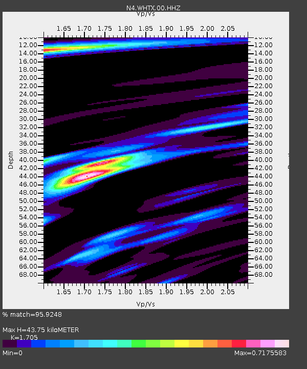
| Estimated Moho Depth: |
43.75 km |
| Estimated Crust Vp/Vs: |
1.71 |
| Assumed Crust Vp: |
6.347 km/s |
| Estimated Crust Vs: |
3.723 km/s |
| Estimated Crust Poisson's Ratio: |
0.24 |
|
| Radial Match: |
95.9248 % |
| Radial Bump: |
290 |
| Transverse Match: |
87.29544 % |
| Transverse Bump: |
400 |
| SOD ConfigId: |
21709731 |
| Insert Time: |
2020-08-11 08:19:38.414 +0000 |
| GWidth: |
2.5 |
| Max Bumps: |
400 |
| Tol: |
0.001 |
|

Signal To Noise
| Channel | StoN | STA | LTA |
| N4:WHTX:00:HHZ:20200728T08:11:58.859009Z | 11.39695 | 7.160008E-7 | 6.2823894E-8 |
| N4:WHTX:00:HH1:20200728T08:11:58.859009Z | 4.711105 | 2.3176331E-7 | 4.919511E-8 |
| N4:WHTX:00:HH2:20200728T08:11:58.859009Z | 2.7715516 | 1.7474167E-7 | 6.3048326E-8 |
| Arrivals |
| Ps | 5.2 SECOND |
| PpPs | 18 SECOND |
| PsPs/PpSs | 23 SECOND |


