You are here: Home > Network List > N4 - Central and EAstern US Network Stations List
> Station Z47B Carrollton, AL, USA > Earthquake Result Viewer
Z47B Carrollton, AL, USA - Earthquake Result Viewer
| Earthquake location: |
Alaska Peninsula |
| Earthquake latitude/longitude: |
54.8/-161.2 |
| Earthquake time(UTC): |
2020/07/28 (210) 08:03:44 GMT |
| Earthquake Depth: |
60 km |
| Earthquake Magnitude: |
5.9 Mi |
| Earthquake Catalog/Contributor: |
NEIC PDE/at |
|
| Network: |
N4 Central and EAstern US Network |
| Station: |
Z47B Carrollton, AL, USA |
| Lat/Lon: |
33.20 N/88.07 W |
| Elevation: |
64 m |
|
| Distance: |
54.2 deg |
| Az: |
81.705 deg |
| Baz: |
316.865 deg |
| Ray Param: |
0.06547864 |
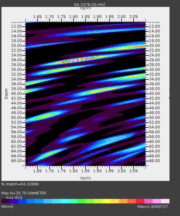
| Estimated Moho Depth: |
25.75 km |
| Estimated Crust Vp/Vs: |
1.82 |
| Assumed Crust Vp: |
6.201 km/s |
| Estimated Crust Vs: |
3.417 km/s |
| Estimated Crust Poisson's Ratio: |
0.28 |
|
| Radial Match: |
94.33899 % |
| Radial Bump: |
400 |
| Transverse Match: |
80.35682 % |
| Transverse Bump: |
400 |
| SOD ConfigId: |
21709731 |
| Insert Time: |
2020-08-11 08:19:54.933 +0000 |
| GWidth: |
2.5 |
| Max Bumps: |
400 |
| Tol: |
0.001 |
|

Signal To Noise
| Channel | StoN | STA | LTA |
| N4:Z47B:00:HHZ:20200728T08:12:32.559998Z | 16.271624 | 9.4908313E-7 | 5.8327497E-8 |
| N4:Z47B:00:HH1:20200728T08:12:32.559998Z | 3.8205001 | 3.053046E-7 | 7.991221E-8 |
| N4:Z47B:00:HH2:20200728T08:12:32.559998Z | 3.1512408 | 3.1916858E-7 | 1.0128347E-7 |
| Arrivals |
| Ps | 3.6 SECOND |
| PpPs | 11 SECOND |
| PsPs/PpSs | 15 SECOND |


