You are here: Home > Network List > O2 - Oklahoma Consolidated Temporary Seismic Networks Stations List
> Station FW03 Mooreland, Oklahoma, USA > Earthquake Result Viewer
FW03 Mooreland, Oklahoma, USA - Earthquake Result Viewer
| Earthquake location: |
Alaska Peninsula |
| Earthquake latitude/longitude: |
54.8/-161.2 |
| Earthquake time(UTC): |
2020/07/28 (210) 08:03:44 GMT |
| Earthquake Depth: |
60 km |
| Earthquake Magnitude: |
5.9 Mi |
| Earthquake Catalog/Contributor: |
NEIC PDE/at |
|
| Network: |
O2 Oklahoma Consolidated Temporary Seismic Networks |
| Station: |
FW03 Mooreland, Oklahoma, USA |
| Lat/Lon: |
36.53 N/99.17 W |
| Elevation: |
628 m |
|
| Distance: |
45.4 deg |
| Az: |
87.184 deg |
| Baz: |
314.08 deg |
| Ray Param: |
0.07112876 |
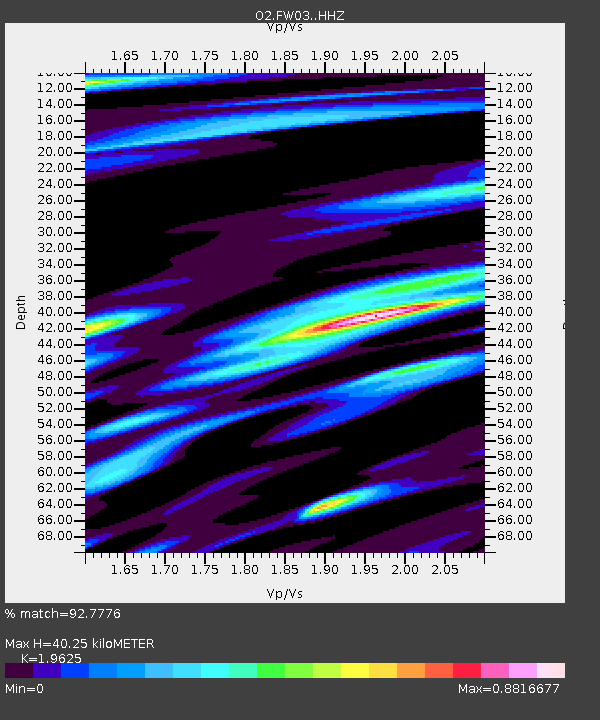
| Estimated Moho Depth: |
40.25 km |
| Estimated Crust Vp/Vs: |
1.96 |
| Assumed Crust Vp: |
6.426 km/s |
| Estimated Crust Vs: |
3.274 km/s |
| Estimated Crust Poisson's Ratio: |
0.32 |
|
| Radial Match: |
92.7776 % |
| Radial Bump: |
400 |
| Transverse Match: |
84.41557 % |
| Transverse Bump: |
400 |
| SOD ConfigId: |
21709731 |
| Insert Time: |
2020-08-11 08:21:54.317 +0000 |
| GWidth: |
2.5 |
| Max Bumps: |
400 |
| Tol: |
0.001 |
|

Signal To Noise
| Channel | StoN | STA | LTA |
| O2:FW03: :HHZ:20200728T08:11:26.13501Z | 6.993247 | 6.805997E-7 | 9.732242E-8 |
| O2:FW03: :HHN:20200728T08:11:26.13501Z | 2.031044 | 2.0418965E-7 | 1.0053433E-7 |
| O2:FW03: :HHE:20200728T08:11:26.13501Z | 2.2640014 | 2.1962768E-7 | 9.700864E-8 |
| Arrivals |
| Ps | 6.4 SECOND |
| PpPs | 18 SECOND |
| PsPs/PpSs | 24 SECOND |


