You are here: Home > Network List > O2 - Oklahoma Consolidated Temporary Seismic Networks Stations List
> Station GORE Near Medford, Oklahoma, USA > Earthquake Result Viewer
GORE Near Medford, Oklahoma, USA - Earthquake Result Viewer
| Earthquake location: |
Alaska Peninsula |
| Earthquake latitude/longitude: |
54.8/-161.2 |
| Earthquake time(UTC): |
2020/07/28 (210) 08:03:44 GMT |
| Earthquake Depth: |
60 km |
| Earthquake Magnitude: |
5.9 Mi |
| Earthquake Catalog/Contributor: |
NEIC PDE/at |
|
| Network: |
O2 Oklahoma Consolidated Temporary Seismic Networks |
| Station: |
GORE Near Medford, Oklahoma, USA |
| Lat/Lon: |
36.79 N/97.95 W |
| Elevation: |
348 m |
|
| Distance: |
45.9 deg |
| Az: |
85.966 deg |
| Baz: |
313.958 deg |
| Ray Param: |
0.07081128 |
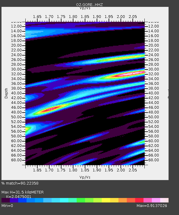
| Estimated Moho Depth: |
31.5 km |
| Estimated Crust Vp/Vs: |
2.05 |
| Assumed Crust Vp: |
6.483 km/s |
| Estimated Crust Vs: |
3.166 km/s |
| Estimated Crust Poisson's Ratio: |
0.34 |
|
| Radial Match: |
90.22358 % |
| Radial Bump: |
400 |
| Transverse Match: |
71.351944 % |
| Transverse Bump: |
400 |
| SOD ConfigId: |
21709731 |
| Insert Time: |
2020-08-11 08:22:06.151 +0000 |
| GWidth: |
2.5 |
| Max Bumps: |
400 |
| Tol: |
0.001 |
|

Signal To Noise
| Channel | StoN | STA | LTA |
| O2:GORE: :HHZ:20200728T08:11:30.299988Z | 6.672815 | 3.2262216E-7 | 4.8348735E-8 |
| O2:GORE: :HHN:20200728T08:11:30.299988Z | 3.2357337 | 1.381193E-7 | 4.2685617E-8 |
| O2:GORE: :HHE:20200728T08:11:30.299988Z | 2.832311 | 1.3156038E-7 | 4.6449838E-8 |
| Arrivals |
| Ps | 5.4 SECOND |
| PpPs | 14 SECOND |
| PsPs/PpSs | 19 SECOND |


