You are here: Home > Network List > O2 - Oklahoma Consolidated Temporary Seismic Networks Stations List
> Station PW09 Ralston, Oklahoma > Earthquake Result Viewer
PW09 Ralston, Oklahoma - Earthquake Result Viewer
| Earthquake location: |
Alaska Peninsula |
| Earthquake latitude/longitude: |
54.8/-161.2 |
| Earthquake time(UTC): |
2020/07/28 (210) 08:03:44 GMT |
| Earthquake Depth: |
60 km |
| Earthquake Magnitude: |
5.9 Mi |
| Earthquake Catalog/Contributor: |
NEIC PDE/at |
|
| Network: |
O2 Oklahoma Consolidated Temporary Seismic Networks |
| Station: |
PW09 Ralston, Oklahoma |
| Lat/Lon: |
36.45 N/96.82 W |
| Elevation: |
291 m |
|
| Distance: |
46.8 deg |
| Az: |
85.426 deg |
| Baz: |
314.257 deg |
| Ray Param: |
0.07023526 |
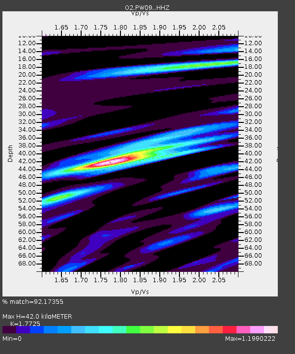
| Estimated Moho Depth: |
42.0 km |
| Estimated Crust Vp/Vs: |
1.77 |
| Assumed Crust Vp: |
6.483 km/s |
| Estimated Crust Vs: |
3.657 km/s |
| Estimated Crust Poisson's Ratio: |
0.27 |
|
| Radial Match: |
92.17355 % |
| Radial Bump: |
390 |
| Transverse Match: |
75.934326 % |
| Transverse Bump: |
400 |
| SOD ConfigId: |
21709731 |
| Insert Time: |
2020-08-11 08:22:21.674 +0000 |
| GWidth: |
2.5 |
| Max Bumps: |
400 |
| Tol: |
0.001 |
|

Signal To Noise
| Channel | StoN | STA | LTA |
| O2:PW09: :HHZ:20200728T08:11:37.250Z | 9.206634 | 4.879107E-7 | 5.2995563E-8 |
| O2:PW09: :HHN:20200728T08:11:37.250Z | 3.9767983 | 1.9585262E-7 | 4.9248822E-8 |
| O2:PW09: :HHE:20200728T08:11:37.250Z | 3.8594465 | 2.2454707E-7 | 5.8181158E-8 |
| Arrivals |
| Ps | 5.3 SECOND |
| PpPs | 17 SECOND |
| PsPs/PpSs | 22 SECOND |


