You are here: Home > Network List > O2 - Oklahoma Consolidated Temporary Seismic Networks Stations List
> Station SC07 Cyril, Oklahoma, USA > Earthquake Result Viewer
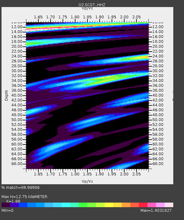
SC07 Cyril, Oklahoma, USA - Earthquake Result Viewer
| Earthquake location: |
Alaska Peninsula |
| Earthquake latitude/longitude: |
54.8/-161.2 |
| Earthquake time(UTC): |
2020/07/28 (210) 08:03:44 GMT |
| Earthquake Depth: |
60 km |
| Earthquake Magnitude: |
5.9 Mi |
| Earthquake Catalog/Contributor: |
NEIC PDE/at |
|
| Network: |
O2 Oklahoma Consolidated Temporary Seismic Networks |
| Station: |
SC07 Cyril, Oklahoma, USA |
| Lat/Lon: |
34.93 N/98.21 W |
| Elevation: |
349 m |
|
| Distance: |
47.1 deg |
| Az: |
87.991 deg |
| Baz: |
315.196 deg |
| Ray Param: |
0.07006273 |
| Estimated Moho Depth: |
12.75 km |
| Estimated Crust Vp/Vs: |
1.69 |
| Assumed Crust Vp: |
6.315 km/s |
| Estimated Crust Vs: |
3.737 km/s |
| Estimated Crust Poisson's Ratio: |
0.23 |
|
| Radial Match: |
89.96986 % |
| Radial Bump: |
322 |
| Transverse Match: |
73.37027 % |
| Transverse Bump: |
400 |
| SOD ConfigId: |
21709731 |
| Insert Time: |
2020-08-11 08:22:39.496 +0000 |
| GWidth: |
2.5 |
| Max Bumps: |
400 |
| Tol: |
0.001 |
|

Signal To Noise
| Channel | StoN | STA | LTA |
| O2:SC07: :HHZ:20200728T08:11:39.234985Z | 7.2543287 | 8.010773E-7 | 1.10427486E-7 |
| O2:SC07: :HHN:20200728T08:11:39.234985Z | 2.3521423 | 3.1010495E-7 | 1.3183937E-7 |
| O2:SC07: :HHE:20200728T08:11:39.234985Z | 1.3870856 | 2.6573352E-7 | 1.9157689E-7 |
| Arrivals |
| Ps | 1.5 SECOND |
| PpPs | 5.1 SECOND |
| PsPs/PpSs | 6.6 SECOND |


