You are here: Home > Network List > O2 - Oklahoma Consolidated Temporary Seismic Networks Stations List
> Station SC17 Lindsey, Oklahoma, USA > Earthquake Result Viewer
SC17 Lindsey, Oklahoma, USA - Earthquake Result Viewer
| Earthquake location: |
Alaska Peninsula |
| Earthquake latitude/longitude: |
54.8/-161.2 |
| Earthquake time(UTC): |
2020/07/28 (210) 08:03:44 GMT |
| Earthquake Depth: |
60 km |
| Earthquake Magnitude: |
5.9 Mi |
| Earthquake Catalog/Contributor: |
NEIC PDE/at |
|
| Network: |
O2 Oklahoma Consolidated Temporary Seismic Networks |
| Station: |
SC17 Lindsey, Oklahoma, USA |
| Lat/Lon: |
34.92 N/97.60 W |
| Elevation: |
1126 m |
|
| Distance: |
47.4 deg |
| Az: |
87.519 deg |
| Baz: |
315.227 deg |
| Ray Param: |
0.069837935 |
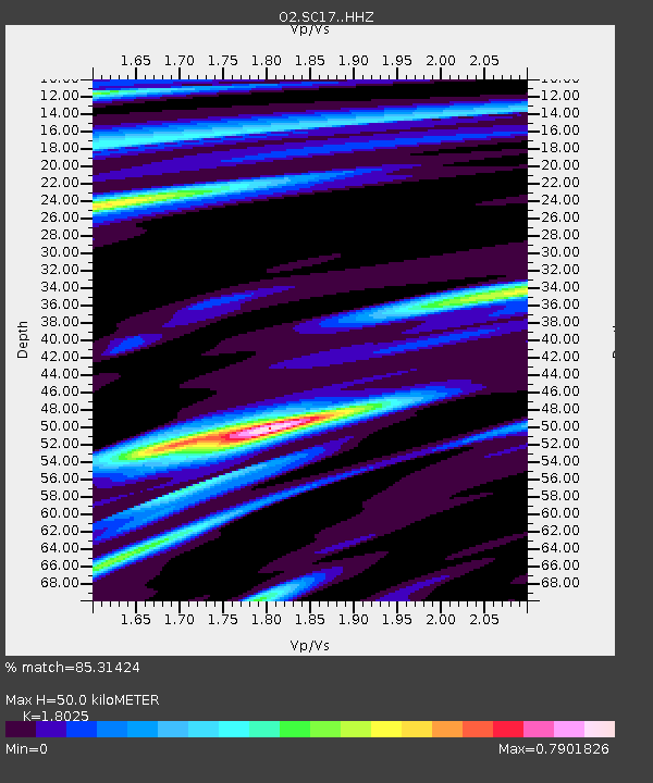
| Estimated Moho Depth: |
50.0 km |
| Estimated Crust Vp/Vs: |
1.80 |
| Assumed Crust Vp: |
6.426 km/s |
| Estimated Crust Vs: |
3.565 km/s |
| Estimated Crust Poisson's Ratio: |
0.28 |
|
| Radial Match: |
85.31424 % |
| Radial Bump: |
400 |
| Transverse Match: |
82.49787 % |
| Transverse Bump: |
400 |
| SOD ConfigId: |
21709731 |
| Insert Time: |
2020-08-11 08:22:54.415 +0000 |
| GWidth: |
2.5 |
| Max Bumps: |
400 |
| Tol: |
0.001 |
|

Signal To Noise
| Channel | StoN | STA | LTA |
| O2:SC17: :HHZ:20200728T08:11:42.095001Z | 5.453018 | 4.9318385E-7 | 9.044236E-8 |
| O2:SC17: :HHN:20200728T08:11:42.095001Z | 1.5752782 | 1.7110396E-7 | 1.0861825E-7 |
| O2:SC17: :HHE:20200728T08:11:42.095001Z | 1.2653072 | 1.2187566E-7 | 9.632101E-8 |
| Arrivals |
| Ps | 6.6 SECOND |
| PpPs | 21 SECOND |
| PsPs/PpSs | 27 SECOND |


