You are here: Home > Network List > OH - Ohio Seismic Network Stations List
> Station CPOH Chapparal Prarie > Earthquake Result Viewer
CPOH Chapparal Prarie - Earthquake Result Viewer
| Earthquake location: |
Alaska Peninsula |
| Earthquake latitude/longitude: |
54.8/-161.2 |
| Earthquake time(UTC): |
2020/07/28 (210) 08:03:44 GMT |
| Earthquake Depth: |
60 km |
| Earthquake Magnitude: |
5.9 Mi |
| Earthquake Catalog/Contributor: |
NEIC PDE/at |
|
| Network: |
OH Ohio Seismic Network |
| Station: |
CPOH Chapparal Prarie |
| Lat/Lon: |
38.84 N/83.58 W |
| Elevation: |
289 m |
|
| Distance: |
52.7 deg |
| Az: |
73.564 deg |
| Baz: |
314.642 deg |
| Ray Param: |
0.066455446 |
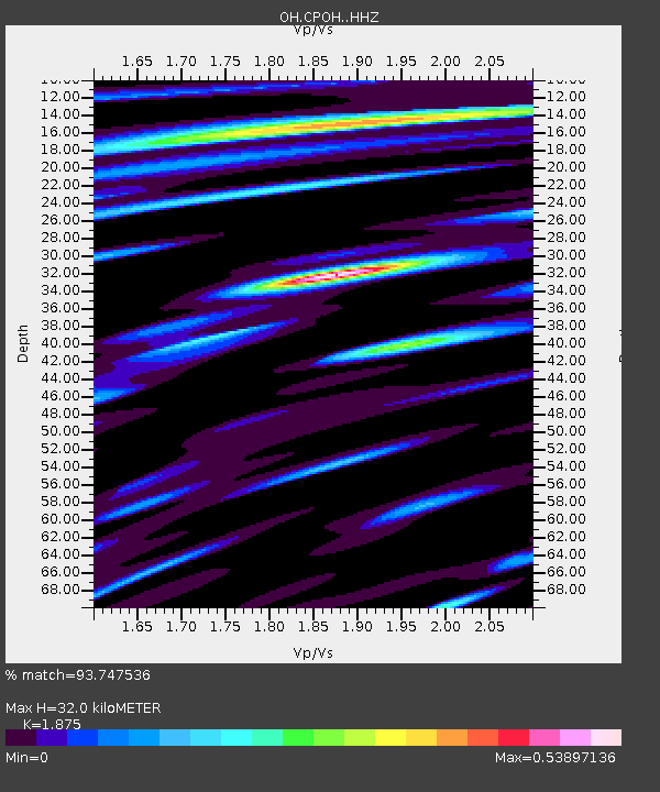
| Estimated Moho Depth: |
32.0 km |
| Estimated Crust Vp/Vs: |
1.88 |
| Assumed Crust Vp: |
6.232 km/s |
| Estimated Crust Vs: |
3.324 km/s |
| Estimated Crust Poisson's Ratio: |
0.30 |
|
| Radial Match: |
93.747536 % |
| Radial Bump: |
251 |
| Transverse Match: |
79.2839 % |
| Transverse Bump: |
400 |
| SOD ConfigId: |
21709731 |
| Insert Time: |
2020-08-11 08:23:13.092 +0000 |
| GWidth: |
2.5 |
| Max Bumps: |
400 |
| Tol: |
0.001 |
|

Signal To Noise
| Channel | StoN | STA | LTA |
| OH:CPOH: :HHZ:20200728T08:12:21.655029Z | 19.527737 | 3.0453393E-8 | 1.5594944E-9 |
| OH:CPOH: :HHN:20200728T08:12:21.655029Z | 8.517918 | 1.7360655E-8 | 2.0381337E-9 |
| OH:CPOH: :HHE:20200728T08:12:21.655029Z | 6.550057 | 1.2572052E-8 | 1.9193804E-9 |
| Arrivals |
| Ps | 4.7 SECOND |
| PpPs | 14 SECOND |
| PsPs/PpSs | 19 SECOND |


