You are here: Home > Network List > OX - North-East Italy Seismic Network Stations List
> Station PRED Cave del Predil > Earthquake Result Viewer
PRED Cave del Predil - Earthquake Result Viewer
| Earthquake location: |
Alaska Peninsula |
| Earthquake latitude/longitude: |
54.8/-161.2 |
| Earthquake time(UTC): |
2020/07/28 (210) 08:03:44 GMT |
| Earthquake Depth: |
60 km |
| Earthquake Magnitude: |
5.9 Mi |
| Earthquake Catalog/Contributor: |
NEIC PDE/at |
|
| Network: |
OX North-East Italy Seismic Network |
| Station: |
PRED Cave del Predil |
| Lat/Lon: |
46.44 N/13.56 E |
| Elevation: |
902 m |
|
| Distance: |
79.1 deg |
| Az: |
3.711 deg |
| Baz: |
356.891 deg |
| Ray Param: |
0.049112845 |
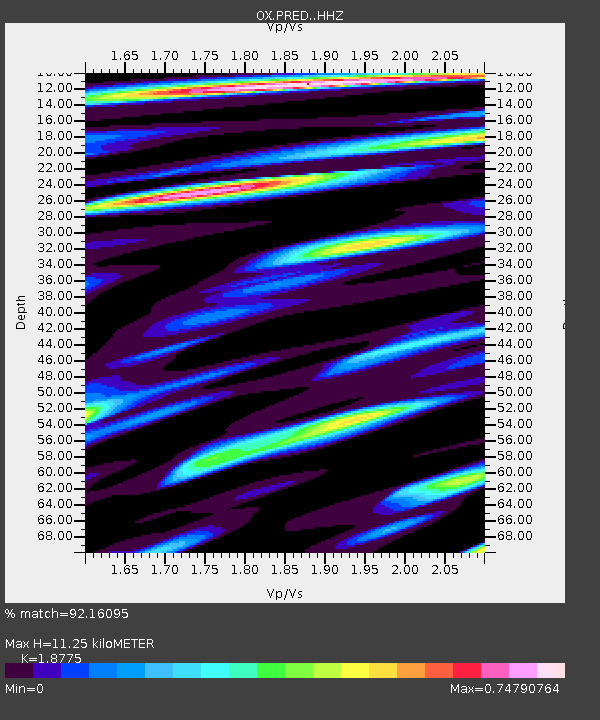
| Estimated Moho Depth: |
11.25 km |
| Estimated Crust Vp/Vs: |
1.88 |
| Assumed Crust Vp: |
6.35 km/s |
| Estimated Crust Vs: |
3.382 km/s |
| Estimated Crust Poisson's Ratio: |
0.30 |
|
| Radial Match: |
92.16095 % |
| Radial Bump: |
338 |
| Transverse Match: |
70.28168 % |
| Transverse Bump: |
400 |
| SOD ConfigId: |
21709731 |
| Insert Time: |
2020-08-11 08:24:06.739 +0000 |
| GWidth: |
2.5 |
| Max Bumps: |
400 |
| Tol: |
0.001 |
|

Signal To Noise
| Channel | StoN | STA | LTA |
| OX:PRED: :HHZ:20200728T08:15:10.728027Z | 9.71062 | 3.7462212E-7 | 3.8578598E-8 |
| OX:PRED: :HHN:20200728T08:15:10.728027Z | 8.369457 | 2.7908428E-7 | 3.3345565E-8 |
| OX:PRED: :HHE:20200728T08:15:10.728027Z | 2.5236433 | 1.2673604E-7 | 5.0219477E-8 |
| Arrivals |
| Ps | 1.6 SECOND |
| PpPs | 5.0 SECOND |
| PsPs/PpSs | 6.6 SECOND |


