You are here: Home > Network List > PE - Penn State Network Stations List
> Station PAGS PA Geological Survey, Middletown, PA > Earthquake Result Viewer
PAGS PA Geological Survey, Middletown, PA - Earthquake Result Viewer

| Earthquake location: |
Alaska Peninsula |
| Earthquake latitude/longitude: |
54.8/-161.2 |
| Earthquake time(UTC): |
2020/07/28 (210) 08:03:44 GMT |
| Earthquake Depth: |
60 km |
| Earthquake Magnitude: |
5.9 Mi |
| Earthquake Catalog/Contributor: |
NEIC PDE/at |
|
| Network: |
PE Penn State Network |
| Station: |
PAGS PA Geological Survey, Middletown, PA |
| Lat/Lon: |
40.23 N/76.72 W |
| Elevation: |
120 m |
|
| Distance: |
55.4 deg |
| Az: |
67.716 deg |
| Baz: |
315.557 deg |
| Ray Param: |
0.06464258 |
| Estimated Moho Depth: |
16.5 km |
| Estimated Crust Vp/Vs: |
1.73 |
| Assumed Crust Vp: |
6.121 km/s |
| Estimated Crust Vs: |
3.548 km/s |
| Estimated Crust Poisson's Ratio: |
0.25 |
|
| Radial Match: |
85.55186 % |
| Radial Bump: |
400 |
| Transverse Match: |
79.47475 % |
| Transverse Bump: |
400 |
| SOD ConfigId: |
21709731 |
| Insert Time: |
2020-08-11 08:24:22.445 +0000 |
| GWidth: |
2.5 |
| Max Bumps: |
400 |
| Tol: |
0.001 |
|
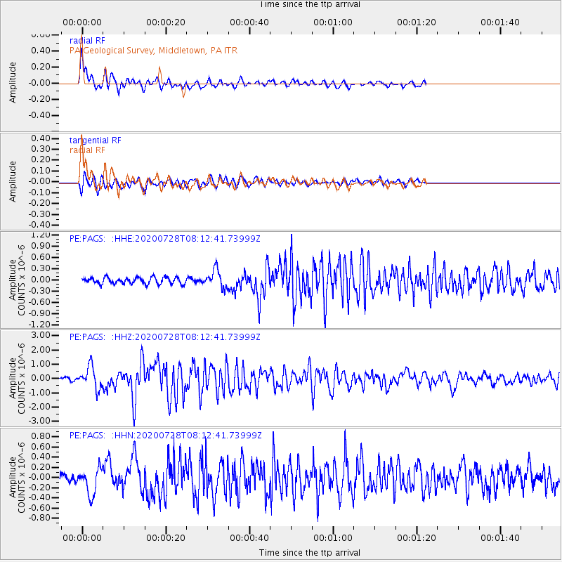
Signal To Noise
| Channel | StoN | STA | LTA |
| PE:PAGS: :HHZ:20200728T08:12:41.73999Z | 7.525861 | 7.958958E-7 | 1.05754786E-7 |
| PE:PAGS: :HHN:20200728T08:12:41.73999Z | 2.3610296 | 2.6145688E-7 | 1.10738505E-7 |
| PE:PAGS: :HHE:20200728T08:12:41.73999Z | 2.8880076 | 2.4284245E-7 | 8.4086494E-8 |
| Arrivals |
| Ps | 2.1 SECOND |
| PpPs | 7.0 SECOND |
| PsPs/PpSs | 9.1 SECOND |


