You are here: Home > Network List > PL - Polish Seismological Network Stations List
> Station SUW PLSN/GEOFON Station Suwalki, Poland > Earthquake Result Viewer
SUW PLSN/GEOFON Station Suwalki, Poland - Earthquake Result Viewer
| Earthquake location: |
Alaska Peninsula |
| Earthquake latitude/longitude: |
54.8/-161.2 |
| Earthquake time(UTC): |
2020/07/28 (210) 08:03:44 GMT |
| Earthquake Depth: |
60 km |
| Earthquake Magnitude: |
5.9 Mi |
| Earthquake Catalog/Contributor: |
NEIC PDE/at |
|
| Network: |
PL Polish Seismological Network |
| Station: |
SUW PLSN/GEOFON Station Suwalki, Poland |
| Lat/Lon: |
54.01 N/23.18 E |
| Elevation: |
152 m |
|
| Distance: |
71.5 deg |
| Az: |
357.299 deg |
| Baz: |
2.651 deg |
| Ray Param: |
0.054160345 |
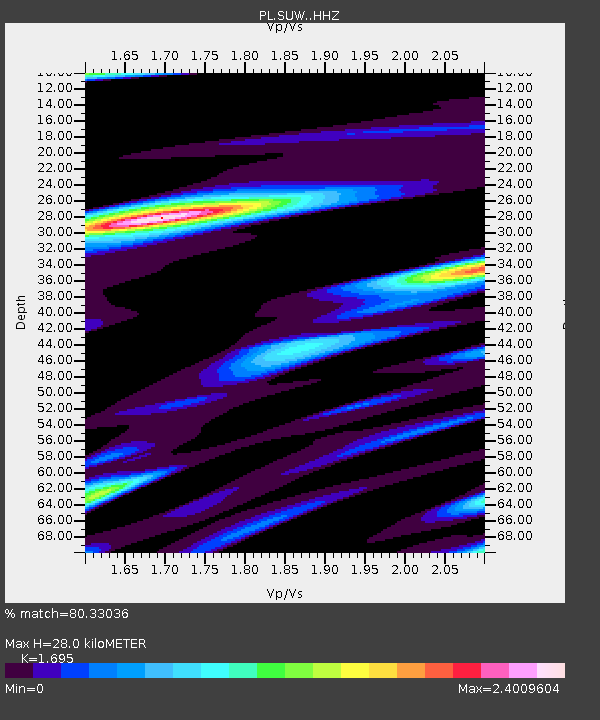
| Estimated Moho Depth: |
28.0 km |
| Estimated Crust Vp/Vs: |
1.70 |
| Assumed Crust Vp: |
6.53 km/s |
| Estimated Crust Vs: |
3.853 km/s |
| Estimated Crust Poisson's Ratio: |
0.23 |
|
| Radial Match: |
80.33036 % |
| Radial Bump: |
400 |
| Transverse Match: |
68.58599 % |
| Transverse Bump: |
400 |
| SOD ConfigId: |
21709731 |
| Insert Time: |
2020-08-11 08:24:55.264 +0000 |
| GWidth: |
2.5 |
| Max Bumps: |
400 |
| Tol: |
0.001 |
|

Signal To Noise
| Channel | StoN | STA | LTA |
| PL:SUW: :HHZ:20200728T08:14:27.583008Z | 6.1214795 | 1.0527253E-6 | 1.7197237E-7 |
| PL:SUW: :HHN:20200728T08:14:27.583008Z | 2.7306166 | 6.189871E-7 | 2.2668401E-7 |
| PL:SUW: :HHE:20200728T08:14:27.583008Z | 1.3542955 | 3.5608102E-7 | 2.6292713E-7 |
| Arrivals |
| Ps | 3.1 SECOND |
| PpPs | 11 SECOND |
| PsPs/PpSs | 14 SECOND |


