You are here: Home > Network List > TJ - Tajikistan National Seismic Network Stations List
> Station SHAA Shaartuz, Tajikistan > Earthquake Result Viewer
SHAA Shaartuz, Tajikistan - Earthquake Result Viewer
| Earthquake location: |
Alaska Peninsula |
| Earthquake latitude/longitude: |
54.8/-161.2 |
| Earthquake time(UTC): |
2020/07/28 (210) 08:03:44 GMT |
| Earthquake Depth: |
60 km |
| Earthquake Magnitude: |
5.9 Mi |
| Earthquake Catalog/Contributor: |
NEIC PDE/at |
|
| Network: |
TJ Tajikistan National Seismic Network |
| Station: |
SHAA Shaartuz, Tajikistan |
| Lat/Lon: |
37.56 N/68.12 E |
| Elevation: |
868 m |
|
| Distance: |
78.8 deg |
| Az: |
322.117 deg |
| Baz: |
26.594 deg |
| Ray Param: |
0.049291693 |
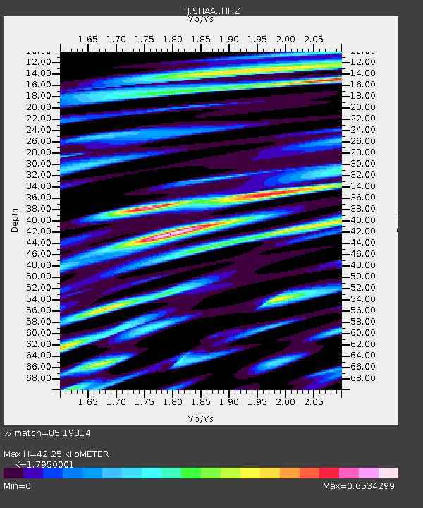
| Estimated Moho Depth: |
42.25 km |
| Estimated Crust Vp/Vs: |
1.80 |
| Assumed Crust Vp: |
6.213 km/s |
| Estimated Crust Vs: |
3.462 km/s |
| Estimated Crust Poisson's Ratio: |
0.27 |
|
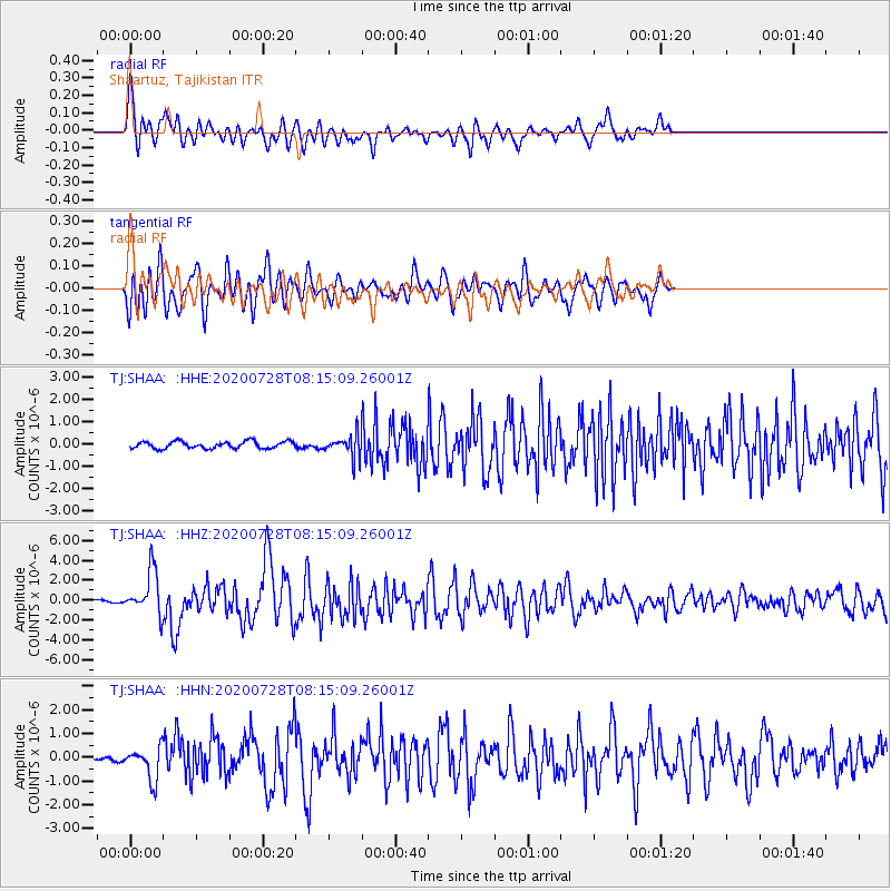
| Radial Match: |
85.19814 % |
| Radial Bump: |
400 |
| Transverse Match: |
81.410904 % |
| Transverse Bump: |
400 |
| SOD ConfigId: |
21709731 |
| Insert Time: |
2020-08-11 08:27:03.312 +0000 |
| GWidth: |
2.5 |
| Max Bumps: |
400 |
| Tol: |
0.001 |
|
Signal To Noise
| Channel | StoN | STA | LTA |
| TJ:SHAA: :HHZ:20200728T08:15:09.26001Z | 16.030024 | 2.152606E-6 | 1.3428587E-7 |
| TJ:SHAA: :HHN:20200728T08:15:09.26001Z | 5.0440836 | 6.7546483E-7 | 1.339123E-7 |
| TJ:SHAA: :HHE:20200728T08:15:09.26001Z | 3.0912578 | 4.821819E-7 | 1.5598245E-7 |
| Arrivals |
| Ps | 5.6 SECOND |
| PpPs | 18 SECOND |
| PsPs/PpSs | 24 SECOND |


