You are here: Home > Network List > TX - Texas Seismological Network Stations List
> Station FW05 UT at Dallas > Earthquake Result Viewer
FW05 UT at Dallas - Earthquake Result Viewer
| Earthquake location: |
Alaska Peninsula |
| Earthquake latitude/longitude: |
54.8/-161.2 |
| Earthquake time(UTC): |
2020/07/28 (210) 08:03:44 GMT |
| Earthquake Depth: |
60 km |
| Earthquake Magnitude: |
5.9 Mi |
| Earthquake Catalog/Contributor: |
NEIC PDE/at |
|
| Network: |
TX Texas Seismological Network |
| Station: |
FW05 UT at Dallas |
| Lat/Lon: |
32.99 N/96.75 W |
| Elevation: |
207 m |
|
| Distance: |
49.3 deg |
| Az: |
88.632 deg |
| Baz: |
316.439 deg |
| Ray Param: |
0.06863494 |
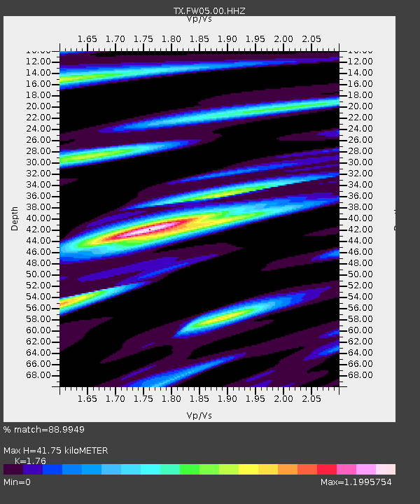
| Estimated Moho Depth: |
41.75 km |
| Estimated Crust Vp/Vs: |
1.76 |
| Assumed Crust Vp: |
6.38 km/s |
| Estimated Crust Vs: |
3.625 km/s |
| Estimated Crust Poisson's Ratio: |
0.26 |
|
| Radial Match: |
88.9949 % |
| Radial Bump: |
289 |
| Transverse Match: |
82.71722 % |
| Transverse Bump: |
400 |
| SOD ConfigId: |
21709731 |
| Insert Time: |
2020-08-11 08:27:38.367 +0000 |
| GWidth: |
2.5 |
| Max Bumps: |
400 |
| Tol: |
0.001 |
|

Signal To Noise
| Channel | StoN | STA | LTA |
| TX:FW05:00:HHZ:20200728T08:11:56.470001Z | 6.6226645 | 6.5299474E-7 | 9.8600005E-8 |
| TX:FW05:00:HH1:20200728T08:11:56.470001Z | 1.9556029 | 2.612082E-7 | 1.3356916E-7 |
| TX:FW05:00:HH2:20200728T08:11:56.470001Z | 1.3170443 | 1.9040179E-7 | 1.445675E-7 |
| Arrivals |
| Ps | 5.3 SECOND |
| PpPs | 17 SECOND |
| PsPs/PpSs | 22 SECOND |


