You are here: Home > Network List > TX - Texas Seismological Network Stations List
> Station FW09 Farmers Branch > Earthquake Result Viewer
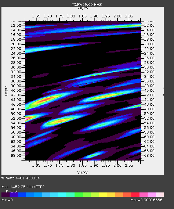
FW09 Farmers Branch - Earthquake Result Viewer
| Earthquake location: |
Alaska Peninsula |
| Earthquake latitude/longitude: |
54.8/-161.2 |
| Earthquake time(UTC): |
2020/07/28 (210) 08:03:44 GMT |
| Earthquake Depth: |
60 km |
| Earthquake Magnitude: |
5.9 Mi |
| Earthquake Catalog/Contributor: |
NEIC PDE/at |
|
| Network: |
TX Texas Seismological Network |
| Station: |
FW09 Farmers Branch |
| Lat/Lon: |
32.92 N/96.91 W |
| Elevation: |
311 m |
|
| Distance: |
49.3 deg |
| Az: |
88.826 deg |
| Baz: |
316.476 deg |
| Ray Param: |
0.06866613 |
| Estimated Moho Depth: |
52.25 km |
| Estimated Crust Vp/Vs: |
1.60 |
| Assumed Crust Vp: |
6.38 km/s |
| Estimated Crust Vs: |
3.988 km/s |
| Estimated Crust Poisson's Ratio: |
0.18 |
|
| Radial Match: |
81.433334 % |
| Radial Bump: |
400 |
| Transverse Match: |
71.44723 % |
| Transverse Bump: |
400 |
| SOD ConfigId: |
21709731 |
| Insert Time: |
2020-08-11 08:27:42.760 +0000 |
| GWidth: |
2.5 |
| Max Bumps: |
400 |
| Tol: |
0.001 |
|

Signal To Noise
| Channel | StoN | STA | LTA |
| TX:FW09:00:HHZ:20200728T08:11:56.100006Z | 1.6023515 | 1.0525463E-6 | 6.5687595E-7 |
| TX:FW09:00:HH1:20200728T08:11:56.100006Z | 1.3562433 | 8.6420795E-7 | 6.372072E-7 |
| TX:FW09:00:HH2:20200728T08:11:56.100006Z | 1.4385463 | 9.0862693E-7 | 6.3162855E-7 |
| Arrivals |
| Ps | 5.2 SECOND |
| PpPs | 20 SECOND |
| PsPs/PpSs | 25 SECOND |


