You are here: Home > Network List > TX - Texas Seismological Network Stations List
> Station PB03 Z > Earthquake Result Viewer
PB03 Z - Earthquake Result Viewer
| Earthquake location: |
Alaska Peninsula |
| Earthquake latitude/longitude: |
54.8/-161.2 |
| Earthquake time(UTC): |
2020/07/28 (210) 08:03:44 GMT |
| Earthquake Depth: |
60 km |
| Earthquake Magnitude: |
5.9 Mi |
| Earthquake Catalog/Contributor: |
NEIC PDE/at |
|
| Network: |
TX Texas Seismological Network |
| Station: |
PB03 Z |
| Lat/Lon: |
31.08 N/103.51 W |
| Elevation: |
817 m |
|
| Distance: |
46.8 deg |
| Az: |
96.031 deg |
| Baz: |
317.815 deg |
| Ray Param: |
0.070253685 |
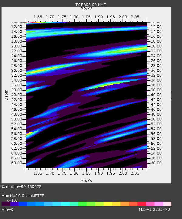
| Estimated Moho Depth: |
10.0 km |
| Estimated Crust Vp/Vs: |
1.60 |
| Assumed Crust Vp: |
6.121 km/s |
| Estimated Crust Vs: |
3.825 km/s |
| Estimated Crust Poisson's Ratio: |
0.18 |
|
| Radial Match: |
90.460075 % |
| Radial Bump: |
400 |
| Transverse Match: |
86.02278 % |
| Transverse Bump: |
400 |
| SOD ConfigId: |
21709731 |
| Insert Time: |
2020-08-11 08:28:02.732 +0000 |
| GWidth: |
2.5 |
| Max Bumps: |
400 |
| Tol: |
0.001 |
|

Signal To Noise
| Channel | StoN | STA | LTA |
| TX:PB03:00:HHZ:20200728T08:11:37.029999Z | 5.2508984 | 2.7309665E-7 | 5.200951E-8 |
| TX:PB03:00:HH1:20200728T08:11:37.029999Z | 1.7542076 | 9.874835E-8 | 5.6292283E-8 |
| TX:PB03:00:HH2:20200728T08:11:37.029999Z | 1.6055068 | 9.8275216E-8 | 6.121134E-8 |
| Arrivals |
| Ps | 1.0 SECOND |
| PpPs | 4.0 SECOND |
| PsPs/PpSs | 5.0 SECOND |


