You are here: Home > Network List > TX - Texas Seismological Network Stations List
> Station SNAG San Augustine > Earthquake Result Viewer
SNAG San Augustine - Earthquake Result Viewer
| Earthquake location: |
Alaska Peninsula |
| Earthquake latitude/longitude: |
54.8/-161.2 |
| Earthquake time(UTC): |
2020/07/28 (210) 08:03:44 GMT |
| Earthquake Depth: |
60 km |
| Earthquake Magnitude: |
5.9 Mi |
| Earthquake Catalog/Contributor: |
NEIC PDE/at |
|
| Network: |
TX Texas Seismological Network |
| Station: |
SNAG San Augustine |
| Lat/Lon: |
31.52 N/94.18 W |
| Elevation: |
84 m |
|
| Distance: |
51.9 deg |
| Az: |
87.873 deg |
| Baz: |
317.322 deg |
| Ray Param: |
0.06696479 |
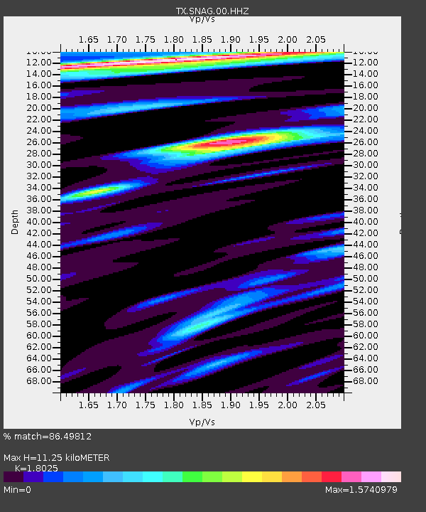
| Estimated Moho Depth: |
11.25 km |
| Estimated Crust Vp/Vs: |
1.80 |
| Assumed Crust Vp: |
5.738 km/s |
| Estimated Crust Vs: |
3.184 km/s |
| Estimated Crust Poisson's Ratio: |
0.28 |
|
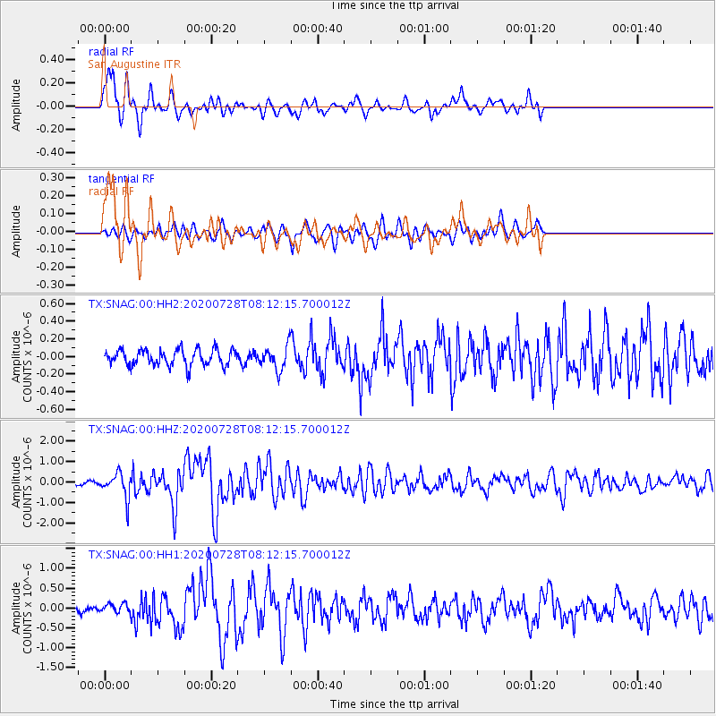
| Radial Match: |
86.49812 % |
| Radial Bump: |
395 |
| Transverse Match: |
66.767395 % |
| Transverse Bump: |
392 |
| SOD ConfigId: |
21709731 |
| Insert Time: |
2020-08-11 08:28:39.375 +0000 |
| GWidth: |
2.5 |
| Max Bumps: |
400 |
| Tol: |
0.001 |
|
Signal To Noise
| Channel | StoN | STA | LTA |
| TX:SNAG:00:HHZ:20200728T08:12:15.700012Z | 4.765604 | 6.184608E-7 | 1.2977594E-7 |
| TX:SNAG:00:HH1:20200728T08:12:15.700012Z | 1.0041692 | 1.11433415E-7 | 1.1097075E-7 |
| TX:SNAG:00:HH2:20200728T08:12:15.700012Z | 1.4846739 | 1.3332371E-7 | 8.98E-8 |
| Arrivals |
| Ps | 1.6 SECOND |
| PpPs | 5.3 SECOND |
| PsPs/PpSs | 6.9 SECOND |


