You are here: Home > Network List > US - United States National Seismic Network Stations List
> Station AMTX Amarillo, Texas, USA > Earthquake Result Viewer
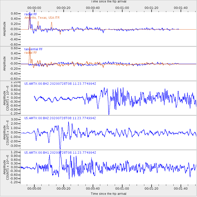
AMTX Amarillo, Texas, USA - Earthquake Result Viewer
*The percent match for this event was below the threshold and hence no stack was calculated.
| Earthquake location: |
Alaska Peninsula |
| Earthquake latitude/longitude: |
54.8/-161.2 |
| Earthquake time(UTC): |
2020/07/28 (210) 08:03:44 GMT |
| Earthquake Depth: |
60 km |
| Earthquake Magnitude: |
5.9 Mi |
| Earthquake Catalog/Contributor: |
NEIC PDE/at |
|
| Network: |
US United States National Seismic Network |
| Station: |
AMTX Amarillo, Texas, USA |
| Lat/Lon: |
34.53 N/101.41 W |
| Elevation: |
1010 m |
|
| Distance: |
45.5 deg |
| Az: |
90.971 deg |
| Baz: |
315.444 deg |
| Ray Param: |
$rayparam |
*The percent match for this event was below the threshold and hence was not used in the summary stack. |
|
| Radial Match: |
91.26534 % |
| Radial Bump: |
400 |
| Transverse Match: |
61.070328 % |
| Transverse Bump: |
400 |
| SOD ConfigId: |
21709731 |
| Insert Time: |
2020-08-11 08:28:54.379 +0000 |
| GWidth: |
2.5 |
| Max Bumps: |
400 |
| Tol: |
0.001 |
|
Signal To Noise
| Channel | StoN | STA | LTA |
| US:AMTX:00:BHZ:20200728T08:11:23.774994Z | 5.912097 | 6.2775246E-7 | 1.0618101E-7 |
| US:AMTX:00:BH1:20200728T08:11:23.774994Z | 2.2484581 | 1.6833388E-7 | 7.4866364E-8 |
| US:AMTX:00:BH2:20200728T08:11:23.774994Z | 1.970617 | 1.8953322E-7 | 9.617963E-8 |
| Arrivals |
| Ps | |
| PpPs | |
| PsPs/PpSs | |


