You are here: Home > Network List > UU - University of Utah Regional Network Stations List
> Station NOQ North Oquirrh Mountains, UT, USA > Earthquake Result Viewer
NOQ North Oquirrh Mountains, UT, USA - Earthquake Result Viewer
| Earthquake location: |
Alaska Peninsula |
| Earthquake latitude/longitude: |
54.8/-161.2 |
| Earthquake time(UTC): |
2020/07/28 (210) 08:03:44 GMT |
| Earthquake Depth: |
60 km |
| Earthquake Magnitude: |
5.9 Mi |
| Earthquake Catalog/Contributor: |
NEIC PDE/at |
|
| Network: |
UU University of Utah Regional Network |
| Station: |
NOQ North Oquirrh Mountains, UT, USA |
| Lat/Lon: |
40.65 N/112.12 W |
| Elevation: |
1622 m |
|
| Distance: |
35.1 deg |
| Az: |
93.044 deg |
| Baz: |
310.503 deg |
| Ray Param: |
0.07722797 |
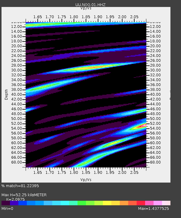
| Estimated Moho Depth: |
52.25 km |
| Estimated Crust Vp/Vs: |
2.10 |
| Assumed Crust Vp: |
6.276 km/s |
| Estimated Crust Vs: |
2.992 km/s |
| Estimated Crust Poisson's Ratio: |
0.35 |
|
| Radial Match: |
81.22395 % |
| Radial Bump: |
400 |
| Transverse Match: |
79.818886 % |
| Transverse Bump: |
400 |
| SOD ConfigId: |
21709731 |
| Insert Time: |
2020-08-11 08:30:26.963 +0000 |
| GWidth: |
2.5 |
| Max Bumps: |
400 |
| Tol: |
0.001 |
|

Signal To Noise
| Channel | StoN | STA | LTA |
| UU:NOQ:01:HHZ:20200728T08:10:01.420013Z | 3.3220139 | 5.38598E-9 | 1.6212998E-9 |
| UU:NOQ:01:HHN:20200728T08:10:01.420013Z | 1.1898569 | 2.1588145E-9 | 1.814348E-9 |
| UU:NOQ:01:HHE:20200728T08:10:01.420013Z | 1.2265519 | 2.0331852E-9 | 1.657643E-9 |
| Arrivals |
| Ps | 9.7 SECOND |
| PpPs | 24 SECOND |
| PsPs/PpSs | 34 SECOND |


