You are here: Home > Network List > YN10 - San Jacinto Fault Zone Stations List
> Station JORD JORD > Earthquake Result Viewer
JORD JORD - Earthquake Result Viewer
| Earthquake location: |
Alaska Peninsula |
| Earthquake latitude/longitude: |
54.8/-161.2 |
| Earthquake time(UTC): |
2020/07/28 (210) 08:03:44 GMT |
| Earthquake Depth: |
60 km |
| Earthquake Magnitude: |
5.9 Mi |
| Earthquake Catalog/Contributor: |
NEIC PDE/at |
|
| Network: |
YN San Jacinto Fault Zone |
| Station: |
JORD JORD |
| Lat/Lon: |
33.47 N/116.64 W |
| Elevation: |
1235 m |
|
| Distance: |
37.6 deg |
| Az: |
105.975 deg |
| Baz: |
318.215 deg |
| Ray Param: |
0.07590129 |
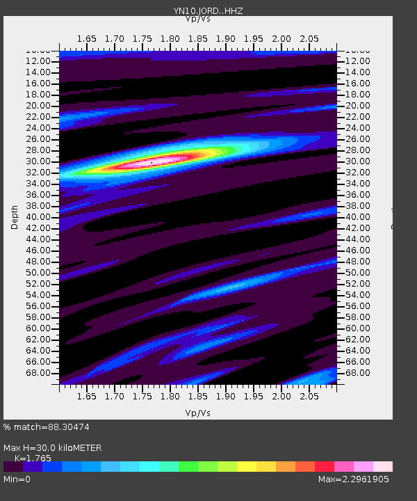
| Estimated Moho Depth: |
30.0 km |
| Estimated Crust Vp/Vs: |
1.76 |
| Assumed Crust Vp: |
6.264 km/s |
| Estimated Crust Vs: |
3.549 km/s |
| Estimated Crust Poisson's Ratio: |
0.26 |
|
| Radial Match: |
88.30474 % |
| Radial Bump: |
306 |
| Transverse Match: |
69.73309 % |
| Transverse Bump: |
400 |
| SOD ConfigId: |
21709731 |
| Insert Time: |
2020-08-11 08:32:15.330 +0000 |
| GWidth: |
2.5 |
| Max Bumps: |
400 |
| Tol: |
0.001 |
|

Signal To Noise
| Channel | StoN | STA | LTA |
| YN:JORD: :HHZ:20200728T08:10:22.104004Z | 3.6685915 | 2.392462E-7 | 6.521473E-8 |
| YN:JORD: :HHN:20200728T08:10:22.104004Z | 1.2263585 | 7.8594105E-8 | 6.408738E-8 |
| YN:JORD: :HHE:20200728T08:10:22.104004Z | 1.4178013 | 1.03121224E-7 | 7.27332E-8 |
| Arrivals |
| Ps | 3.9 SECOND |
| PpPs | 12 SECOND |
| PsPs/PpSs | 16 SECOND |


