You are here: Home > Network List > YX16 - Raton Basin UNM Broadband Network Stations List
> Station UNM5 Southernmost CO Station > Earthquake Result Viewer
UNM5 Southernmost CO Station - Earthquake Result Viewer
| Earthquake location: |
Alaska Peninsula |
| Earthquake latitude/longitude: |
54.8/-161.2 |
| Earthquake time(UTC): |
2020/07/28 (210) 08:03:44 GMT |
| Earthquake Depth: |
60 km |
| Earthquake Magnitude: |
5.9 Mi |
| Earthquake Catalog/Contributor: |
NEIC PDE/at |
|
| Network: |
YX Raton Basin UNM Broadband Network |
| Station: |
UNM5 Southernmost CO Station |
| Lat/Lon: |
37.12 N/104.78 W |
| Elevation: |
2035 m |
|
| Distance: |
41.7 deg |
| Az: |
91.084 deg |
| Baz: |
313.559 deg |
| Ray Param: |
0.0734223 |
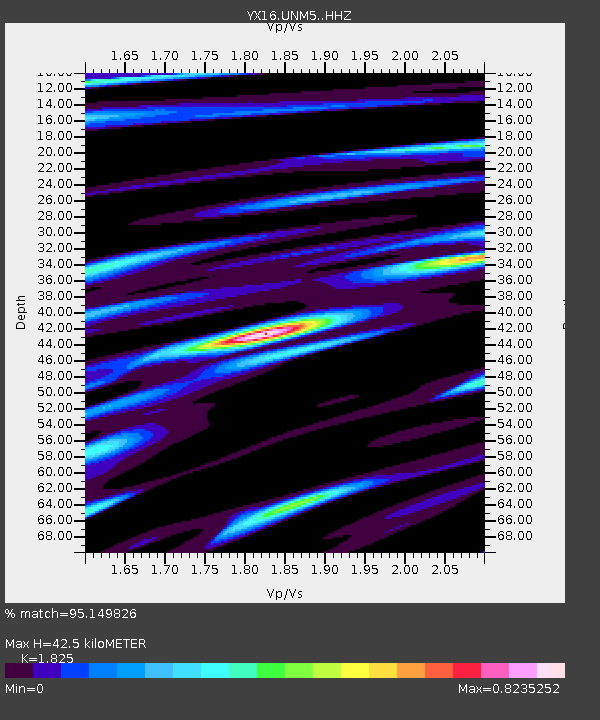
| Estimated Moho Depth: |
42.5 km |
| Estimated Crust Vp/Vs: |
1.83 |
| Assumed Crust Vp: |
6.316 km/s |
| Estimated Crust Vs: |
3.461 km/s |
| Estimated Crust Poisson's Ratio: |
0.29 |
|
| Radial Match: |
95.149826 % |
| Radial Bump: |
371 |
| Transverse Match: |
90.45235 % |
| Transverse Bump: |
400 |
| SOD ConfigId: |
21709731 |
| Insert Time: |
2020-08-11 08:32:24.584 +0000 |
| GWidth: |
2.5 |
| Max Bumps: |
400 |
| Tol: |
0.001 |
|

Signal To Noise
| Channel | StoN | STA | LTA |
| YX:UNM5: :HHZ:20200728T08:10:56.759003Z | 4.2108693 | 1.9752787E-7 | 4.6909047E-8 |
| YX:UNM5: :HHN:20200728T08:10:56.759003Z | 1.9962978 | 8.270157E-8 | 4.1427473E-8 |
| YX:UNM5: :HHE:20200728T08:10:56.759003Z | 1.9639859 | 7.719621E-8 | 3.930589E-8 |
| Arrivals |
| Ps | 5.9 SECOND |
| PpPs | 18 SECOND |
| PsPs/PpSs | 24 SECOND |


