You are here: Home > Network List > AG - Arkansas Seismic Network Stations List
> Station WHAR Woolly Hollow State Park,AR > Earthquake Result Viewer
WHAR Woolly Hollow State Park,AR - Earthquake Result Viewer
| Earthquake location: |
Komandorskiye Ostrova Region |
| Earthquake latitude/longitude: |
54.6/168.6 |
| Earthquake time(UTC): |
2017/07/17 (198) 11:05:08 GMT |
| Earthquake Depth: |
7.9 km |
| Earthquake Magnitude: |
6.2 Mww |
| Earthquake Catalog/Contributor: |
NEIC PDE/us |
|
| Network: |
AG Arkansas Seismic Network |
| Station: |
WHAR Woolly Hollow State Park,AR |
| Lat/Lon: |
35.29 N/92.29 W |
| Elevation: |
184 m |
|
| Distance: |
66.9 deg |
| Az: |
61.447 deg |
| Baz: |
321.314 deg |
| Ray Param: |
0.057325147 |
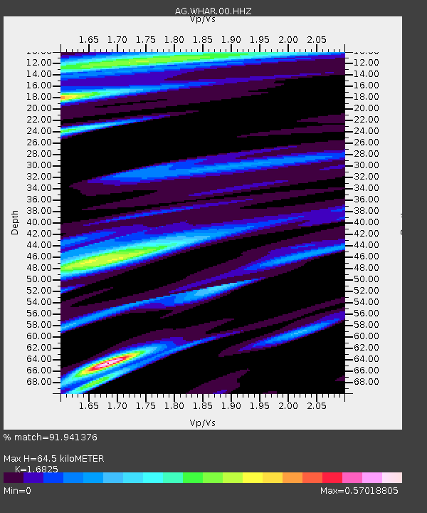
| Estimated Moho Depth: |
64.5 km |
| Estimated Crust Vp/Vs: |
1.68 |
| Assumed Crust Vp: |
6.498 km/s |
| Estimated Crust Vs: |
3.862 km/s |
| Estimated Crust Poisson's Ratio: |
0.23 |
|
| Radial Match: |
91.941376 % |
| Radial Bump: |
288 |
| Transverse Match: |
82.84883 % |
| Transverse Bump: |
296 |
| SOD ConfigId: |
2140511 |
| Insert Time: |
2017-07-31 02:56:51.558 +0000 |
| GWidth: |
2.5 |
| Max Bumps: |
400 |
| Tol: |
0.001 |
|

Signal To Noise
| Channel | StoN | STA | LTA |
| AG:WHAR:00:HHZ:20170717T11:15:30.255002Z | 15.522863 | 1.1080227E-6 | 7.138005E-8 |
| AG:WHAR:00:HHN:20170717T11:15:30.255002Z | 10.294527 | 4.570101E-7 | 4.43935E-8 |
| AG:WHAR:00:HHE:20170717T11:15:30.255002Z | 6.556205 | 2.9429606E-7 | 4.4888175E-8 |
| Arrivals |
| Ps | 7.1 SECOND |
| PpPs | 25 SECOND |
| PsPs/PpSs | 33 SECOND |


