You are here: Home > Network List > N4 - Central and EAstern US Network Stations List
> Station N38B Corydon, IA, USA > Earthquake Result Viewer
N38B Corydon, IA, USA - Earthquake Result Viewer
| Earthquake location: |
Alaska Peninsula |
| Earthquake latitude/longitude: |
55.0/-160.3 |
| Earthquake time(UTC): |
2020/07/29 (211) 09:12:17 GMT |
| Earthquake Depth: |
60 km |
| Earthquake Magnitude: |
5.5 Mi |
| Earthquake Catalog/Contributor: |
NEIC PDE/at |
|
| Network: |
N4 Central and EAstern US Network |
| Station: |
N38B Corydon, IA, USA |
| Lat/Lon: |
40.79 N/93.24 W |
| Elevation: |
322 m |
|
| Distance: |
45.4 deg |
| Az: |
79.201 deg |
| Baz: |
311.811 deg |
| Ray Param: |
0.07112901 |
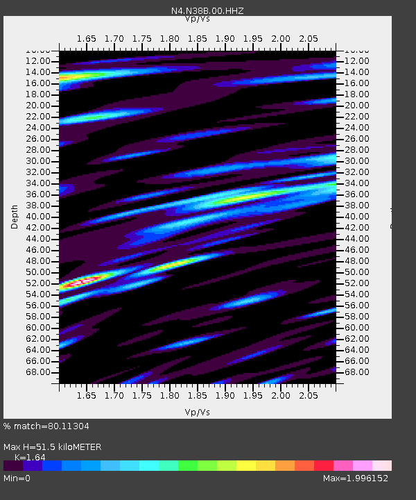
| Estimated Moho Depth: |
51.5 km |
| Estimated Crust Vp/Vs: |
1.64 |
| Assumed Crust Vp: |
6.498 km/s |
| Estimated Crust Vs: |
3.962 km/s |
| Estimated Crust Poisson's Ratio: |
0.20 |
|
| Radial Match: |
80.11304 % |
| Radial Bump: |
400 |
| Transverse Match: |
64.924126 % |
| Transverse Bump: |
400 |
| SOD ConfigId: |
21709731 |
| Insert Time: |
2020-08-12 09:23:33.663 +0000 |
| GWidth: |
2.5 |
| Max Bumps: |
400 |
| Tol: |
0.001 |
|

Signal To Noise
| Channel | StoN | STA | LTA |
| N4:N38B:00:HHZ:20200729T09:19:59.130005Z | 1.9416639 | 1.3930504E-7 | 7.174519E-8 |
| N4:N38B:00:HH1:20200729T09:19:59.130005Z | 1.6086745 | 1.151212E-7 | 7.156277E-8 |
| N4:N38B:00:HH2:20200729T09:19:59.130005Z | 1.2499126 | 7.418878E-8 | 5.9355173E-8 |
| Arrivals |
| Ps | 5.4 SECOND |
| PpPs | 20 SECOND |
| PsPs/PpSs | 25 SECOND |


