You are here: Home > Network List > GS - US Geological Survey Networks Stations List
> Station OK032 Salt Plains WLR near Rte 11, Oklahoma, USA > Earthquake Result Viewer
OK032 Salt Plains WLR near Rte 11, Oklahoma, USA - Earthquake Result Viewer
| Earthquake location: |
Komandorskiye Ostrova Region |
| Earthquake latitude/longitude: |
54.6/168.6 |
| Earthquake time(UTC): |
2017/07/17 (198) 11:05:08 GMT |
| Earthquake Depth: |
7.9 km |
| Earthquake Magnitude: |
6.2 Mww |
| Earthquake Catalog/Contributor: |
NEIC PDE/us |
|
| Network: |
GS US Geological Survey Networks |
| Station: |
OK032 Salt Plains WLR near Rte 11, Oklahoma, USA |
| Lat/Lon: |
36.80 N/98.21 W |
| Elevation: |
345 m |
|
| Distance: |
62.7 deg |
| Az: |
64.456 deg |
| Baz: |
319.126 deg |
| Ray Param: |
0.060090628 |
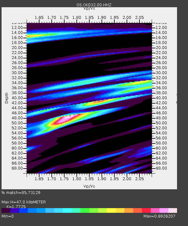
| Estimated Moho Depth: |
47.0 km |
| Estimated Crust Vp/Vs: |
1.77 |
| Assumed Crust Vp: |
6.426 km/s |
| Estimated Crust Vs: |
3.625 km/s |
| Estimated Crust Poisson's Ratio: |
0.27 |
|
| Radial Match: |
85.73129 % |
| Radial Bump: |
365 |
| Transverse Match: |
71.8082 % |
| Transverse Bump: |
400 |
| SOD ConfigId: |
2140511 |
| Insert Time: |
2017-07-31 02:59:23.938 +0000 |
| GWidth: |
2.5 |
| Max Bumps: |
400 |
| Tol: |
0.001 |
|

Signal To Noise
| Channel | StoN | STA | LTA |
| GS:OK032:00:HHZ:20170717T11:15:02.729978Z | 11.279965 | 7.5403796E-7 | 6.684755E-8 |
| GS:OK032:00:HH1:20170717T11:15:02.729978Z | 4.581285 | 3.0746412E-7 | 6.711308E-8 |
| GS:OK032:00:HH2:20170717T11:15:02.729978Z | 4.1041484 | 2.7731656E-7 | 6.7569815E-8 |
| Arrivals |
| Ps | 5.9 SECOND |
| PpPs | 19 SECOND |
| PsPs/PpSs | 25 SECOND |


