You are here: Home > Network List > GS - US Geological Survey Networks Stations List
> Station OK051 E0350 and S34600 Roads, Ralston, OK > Earthquake Result Viewer
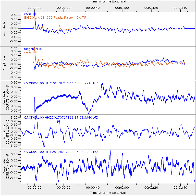
OK051 E0350 and S34600 Roads, Ralston, OK - Earthquake Result Viewer
*The percent match for this event was below the threshold and hence no stack was calculated.
| Earthquake location: |
Komandorskiye Ostrova Region |
| Earthquake latitude/longitude: |
54.6/168.6 |
| Earthquake time(UTC): |
2017/07/17 (198) 11:05:08 GMT |
| Earthquake Depth: |
7.9 km |
| Earthquake Magnitude: |
6.2 Mww |
| Earthquake Catalog/Contributor: |
NEIC PDE/us |
|
| Network: |
GS US Geological Survey Networks |
| Station: |
OK051 E0350 and S34600 Roads, Ralston, OK |
| Lat/Lon: |
36.51 N/96.84 W |
| Elevation: |
263 m |
|
| Distance: |
63.6 deg |
| Az: |
63.733 deg |
| Baz: |
319.617 deg |
| Ray Param: |
$rayparam |
*The percent match for this event was below the threshold and hence was not used in the summary stack. |
|
| Radial Match: |
69.09669 % |
| Radial Bump: |
400 |
| Transverse Match: |
39.49088 % |
| Transverse Bump: |
400 |
| SOD ConfigId: |
2140511 |
| Insert Time: |
2017-07-31 02:59:30.541 +0000 |
| GWidth: |
2.5 |
| Max Bumps: |
400 |
| Tol: |
0.001 |
|
Signal To Noise
| Channel | StoN | STA | LTA |
| GS:OK051:00:HHZ:20170717T11:15:08.994016Z | 6.419879 | 6.8143817E-7 | 1.0614502E-7 |
| GS:OK051:00:HH1:20170717T11:15:08.994016Z | 2.50177 | 1.9493228E-7 | 7.791775E-8 |
| GS:OK051:00:HH2:20170717T11:15:08.994016Z | 1.0361283 | 3.0154092E-7 | 2.910266E-7 |
| Arrivals |
| Ps | |
| PpPs | |
| PsPs/PpSs | |


