You are here: Home > Network List > N4 - Central and EAstern US Network Stations List
> Station K22A Casper, WY, USA > Earthquake Result Viewer
K22A Casper, WY, USA - Earthquake Result Viewer
| Earthquake location: |
Southeast Of Honshu, Japan |
| Earthquake latitude/longitude: |
30.6/141.9 |
| Earthquake time(UTC): |
2020/07/30 (212) 00:35:55 GMT |
| Earthquake Depth: |
9.5 km |
| Earthquake Magnitude: |
5.8 Mww |
| Earthquake Catalog/Contributor: |
NEIC PDE/us |
|
| Network: |
N4 Central and EAstern US Network |
| Station: |
K22A Casper, WY, USA |
| Lat/Lon: |
42.65 N/106.52 W |
| Elevation: |
1686 m |
|
| Distance: |
83.8 deg |
| Az: |
43.623 deg |
| Baz: |
306.293 deg |
| Ray Param: |
0.045936365 |
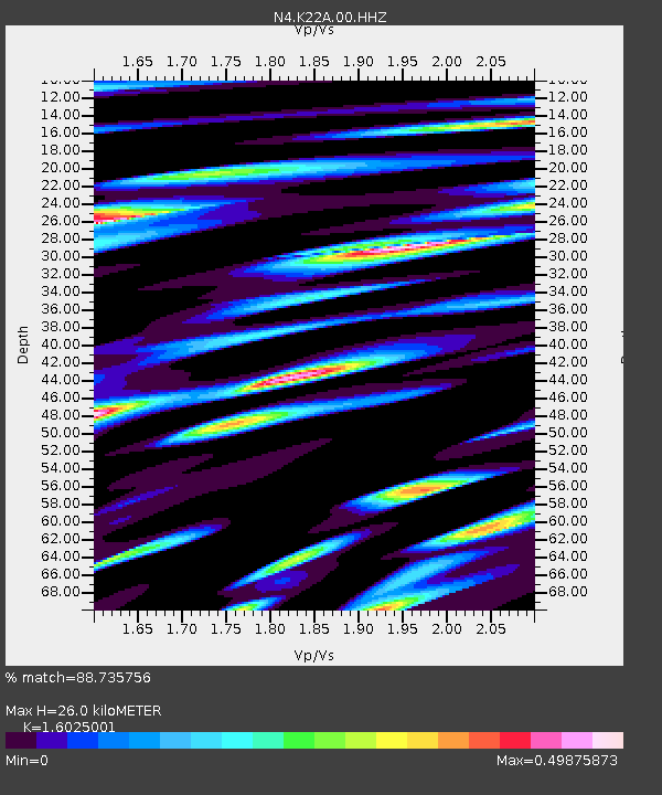
| Estimated Moho Depth: |
26.0 km |
| Estimated Crust Vp/Vs: |
1.60 |
| Assumed Crust Vp: |
6.178 km/s |
| Estimated Crust Vs: |
3.855 km/s |
| Estimated Crust Poisson's Ratio: |
0.18 |
|
| Radial Match: |
88.735756 % |
| Radial Bump: |
360 |
| Transverse Match: |
69.79695 % |
| Transverse Bump: |
400 |
| SOD ConfigId: |
21709731 |
| Insert Time: |
2020-08-13 00:48:55.075 +0000 |
| GWidth: |
2.5 |
| Max Bumps: |
400 |
| Tol: |
0.001 |
|

Signal To Noise
| Channel | StoN | STA | LTA |
| N4:K22A:00:HHZ:20200730T00:47:53.780Z | 2.4222102 | 1.4368312E-7 | 5.9319017E-8 |
| N4:K22A:00:HH1:20200730T00:47:53.780Z | 1.1171533 | 6.0705034E-8 | 5.4339036E-8 |
| N4:K22A:00:HH2:20200730T00:47:53.780Z | 0.8174577 | 4.7371696E-8 | 5.7950025E-8 |
| Arrivals |
| Ps | 2.6 SECOND |
| PpPs | 11 SECOND |
| PsPs/PpSs | 13 SECOND |


