You are here: Home > Network List > GS - US Geological Survey Networks Stations List
> Station MT01 Lincoln Ranger Stn, Helena Natl Forest, Montana, USA > Earthquake Result Viewer
MT01 Lincoln Ranger Stn, Helena Natl Forest, Montana, USA - Earthquake Result Viewer

| Earthquake location: |
Komandorskiye Ostrova Region |
| Earthquake latitude/longitude: |
54.6/168.6 |
| Earthquake time(UTC): |
2017/07/17 (198) 11:05:08 GMT |
| Earthquake Depth: |
7.9 km |
| Earthquake Magnitude: |
6.2 Mww |
| Earthquake Catalog/Contributor: |
NEIC PDE/us |
|
| Network: |
GS US Geological Survey Networks |
| Station: |
MT01 Lincoln Ranger Stn, Helena Natl Forest, Montana, USA |
| Lat/Lon: |
46.95 N/112.66 W |
| Elevation: |
1318 m |
|
| Distance: |
47.9 deg |
| Az: |
64.884 deg |
| Baz: |
309.698 deg |
| Ray Param: |
0.06970727 |
| Estimated Moho Depth: |
41.0 km |
| Estimated Crust Vp/Vs: |
1.66 |
| Assumed Crust Vp: |
6.353 km/s |
| Estimated Crust Vs: |
3.821 km/s |
| Estimated Crust Poisson's Ratio: |
0.22 |
|
| Radial Match: |
87.62275 % |
| Radial Bump: |
400 |
| Transverse Match: |
82.46262 % |
| Transverse Bump: |
400 |
| SOD ConfigId: |
2140511 |
| Insert Time: |
2017-07-31 02:59:40.103 +0000 |
| GWidth: |
2.5 |
| Max Bumps: |
400 |
| Tol: |
0.001 |
|
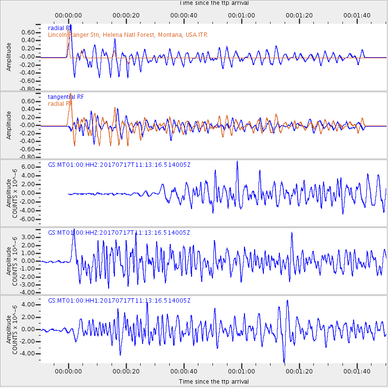
Signal To Noise
| Channel | StoN | STA | LTA |
| GS:MT01:00:HHZ:20170717T11:13:16.514005Z | 22.77475 | 1.7003588E-6 | 7.465982E-8 |
| GS:MT01:00:HH1:20170717T11:13:16.514005Z | 4.7764225 | 9.851378E-7 | 2.0625015E-7 |
| GS:MT01:00:HH2:20170717T11:13:16.514005Z | 9.489741 | 1.1456109E-6 | 1.2072097E-7 |
| Arrivals |
| Ps | 4.6 SECOND |
| PpPs | 16 SECOND |
| PsPs/PpSs | 21 SECOND |


