You are here: Home > Network List > TA - USArray Transportable Network (new EarthScope stations) Stations List
> Station A36M Sachs Harbour, NT, CAN > Earthquake Result Viewer
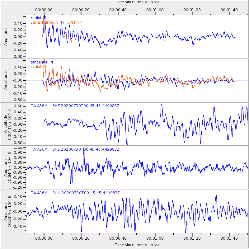
A36M Sachs Harbour, NT, CAN - Earthquake Result Viewer
*The percent match for this event was below the threshold and hence no stack was calculated.
| Earthquake location: |
Southeast Of Honshu, Japan |
| Earthquake latitude/longitude: |
30.6/141.9 |
| Earthquake time(UTC): |
2020/07/30 (212) 00:35:55 GMT |
| Earthquake Depth: |
9.5 km |
| Earthquake Magnitude: |
5.8 Mww |
| Earthquake Catalog/Contributor: |
NEIC PDE/us |
|
| Network: |
TA USArray Transportable Network (new EarthScope stations) |
| Station: |
A36M Sachs Harbour, NT, CAN |
| Lat/Lon: |
71.99 N/125.25 W |
| Elevation: |
32 m |
|
| Distance: |
62.1 deg |
| Az: |
20.59 deg |
| Baz: |
283.023 deg |
| Ray Param: |
$rayparam |
*The percent match for this event was below the threshold and hence was not used in the summary stack. |
|
| Radial Match: |
69.15483 % |
| Radial Bump: |
400 |
| Transverse Match: |
67.9659 % |
| Transverse Bump: |
400 |
| SOD ConfigId: |
21709731 |
| Insert Time: |
2020-08-13 00:53:02.241 +0000 |
| GWidth: |
2.5 |
| Max Bumps: |
400 |
| Tol: |
0.001 |
|
Signal To Noise
| Channel | StoN | STA | LTA |
| TA:A36M: :BHZ:20200730T00:45:45.449983Z | 4.231051 | 2.0053612E-7 | 4.7396288E-8 |
| TA:A36M: :BHN:20200730T00:45:45.449983Z | 1.1646059 | 1.0565331E-7 | 9.072023E-8 |
| TA:A36M: :BHE:20200730T00:45:45.449983Z | 2.8338256 | 2.204219E-7 | 7.778245E-8 |
| Arrivals |
| Ps | |
| PpPs | |
| PsPs/PpSs | |


