You are here: Home > Network List > TA - USArray Transportable Network (new EarthScope stations) Stations List
> Station D23K Nanushuk River, AK USA > Earthquake Result Viewer
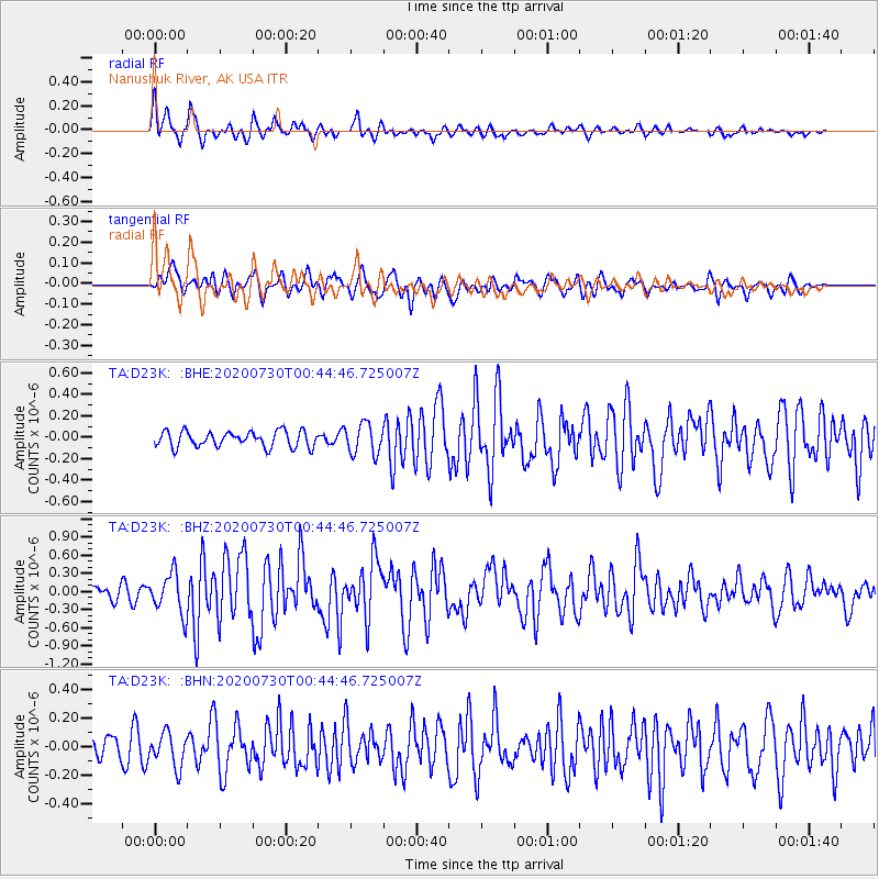
D23K Nanushuk River, AK USA - Earthquake Result Viewer
*The percent match for this event was below the threshold and hence no stack was calculated.
| Earthquake location: |
Southeast Of Honshu, Japan |
| Earthquake latitude/longitude: |
30.6/141.9 |
| Earthquake time(UTC): |
2020/07/30 (212) 00:35:55 GMT |
| Earthquake Depth: |
9.5 km |
| Earthquake Magnitude: |
5.8 Mww |
| Earthquake Catalog/Contributor: |
NEIC PDE/us |
|
| Network: |
TA USArray Transportable Network (new EarthScope stations) |
| Station: |
D23K Nanushuk River, AK USA |
| Lat/Lon: |
68.97 N/150.68 W |
| Elevation: |
406 m |
|
| Distance: |
53.7 deg |
| Az: |
24.444 deg |
| Baz: |
261.073 deg |
| Ray Param: |
$rayparam |
*The percent match for this event was below the threshold and hence was not used in the summary stack. |
|
| Radial Match: |
79.05916 % |
| Radial Bump: |
350 |
| Transverse Match: |
54.39464 % |
| Transverse Bump: |
366 |
| SOD ConfigId: |
21709731 |
| Insert Time: |
2020-08-13 00:53:11.685 +0000 |
| GWidth: |
2.5 |
| Max Bumps: |
400 |
| Tol: |
0.001 |
|
Signal To Noise
| Channel | StoN | STA | LTA |
| TA:D23K: :BHZ:20200730T00:44:46.725007Z | 2.6153936 | 3.314711E-7 | 1.2673851E-7 |
| TA:D23K: :BHN:20200730T00:44:46.725007Z | 1.0289108 | 1.1671866E-7 | 1.1343904E-7 |
| TA:D23K: :BHE:20200730T00:44:46.725007Z | 1.9160566 | 1.4103293E-7 | 7.360582E-8 |
| Arrivals |
| Ps | |
| PpPs | |
| PsPs/PpSs | |


