You are here: Home > Network List > TA - USArray Transportable Network (new EarthScope stations) Stations List
> Station E23K Chandalar, AK, USA > Earthquake Result Viewer
E23K Chandalar, AK, USA - Earthquake Result Viewer
| Earthquake location: |
Southeast Of Honshu, Japan |
| Earthquake latitude/longitude: |
30.6/141.9 |
| Earthquake time(UTC): |
2020/07/30 (212) 00:35:55 GMT |
| Earthquake Depth: |
9.5 km |
| Earthquake Magnitude: |
5.8 Mww |
| Earthquake Catalog/Contributor: |
NEIC PDE/us |
|
| Network: |
TA USArray Transportable Network (new EarthScope stations) |
| Station: |
E23K Chandalar, AK, USA |
| Lat/Lon: |
68.06 N/149.62 W |
| Elevation: |
1084 m |
|
| Distance: |
53.9 deg |
| Az: |
25.631 deg |
| Baz: |
262.763 deg |
| Ray Param: |
0.06576124 |
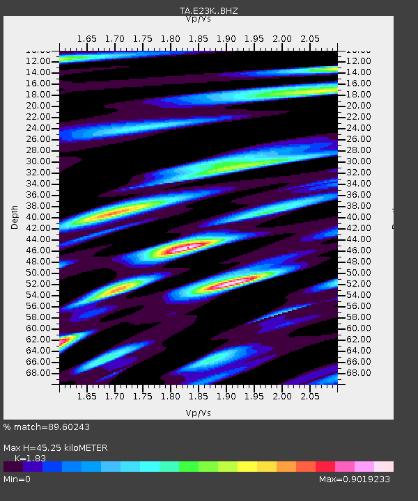
| Estimated Moho Depth: |
45.25 km |
| Estimated Crust Vp/Vs: |
1.83 |
| Assumed Crust Vp: |
6.316 km/s |
| Estimated Crust Vs: |
3.451 km/s |
| Estimated Crust Poisson's Ratio: |
0.29 |
|
| Radial Match: |
89.60243 % |
| Radial Bump: |
400 |
| Transverse Match: |
81.880455 % |
| Transverse Bump: |
395 |
| SOD ConfigId: |
21709731 |
| Insert Time: |
2020-08-13 00:53:21.472 +0000 |
| GWidth: |
2.5 |
| Max Bumps: |
400 |
| Tol: |
0.001 |
|

Signal To Noise
| Channel | StoN | STA | LTA |
| TA:E23K: :BHZ:20200730T00:44:48.624971Z | 3.430818 | 2.383074E-7 | 6.94608E-8 |
| TA:E23K: :BHN:20200730T00:44:48.624971Z | 0.8115083 | 6.156833E-8 | 7.586901E-8 |
| TA:E23K: :BHE:20200730T00:44:48.624971Z | 2.8130262 | 1.08090696E-7 | 3.8425057E-8 |
| Arrivals |
| Ps | 6.3 SECOND |
| PpPs | 19 SECOND |
| PsPs/PpSs | 26 SECOND |


