You are here: Home > Network List > TA - USArray Transportable Network (new EarthScope stations) Stations List
> Station F30M Barrier River, YT, CAN > Earthquake Result Viewer
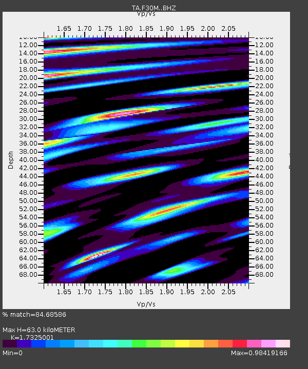
F30M Barrier River, YT, CAN - Earthquake Result Viewer
| Earthquake location: |
Southeast Of Honshu, Japan |
| Earthquake latitude/longitude: |
30.6/141.9 |
| Earthquake time(UTC): |
2020/07/30 (212) 00:35:55 GMT |
| Earthquake Depth: |
9.5 km |
| Earthquake Magnitude: |
5.8 Mww |
| Earthquake Catalog/Contributor: |
NEIC PDE/us |
|
| Network: |
TA USArray Transportable Network (new EarthScope stations) |
| Station: |
F30M Barrier River, YT, CAN |
| Lat/Lon: |
67.61 N/135.79 W |
| Elevation: |
414 m |
|
| Distance: |
59.2 deg |
| Az: |
26.239 deg |
| Baz: |
275.903 deg |
| Ray Param: |
0.06236402 |
| Estimated Moho Depth: |
63.0 km |
| Estimated Crust Vp/Vs: |
1.73 |
| Assumed Crust Vp: |
6.171 km/s |
| Estimated Crust Vs: |
3.562 km/s |
| Estimated Crust Poisson's Ratio: |
0.25 |
|
| Radial Match: |
84.68586 % |
| Radial Bump: |
400 |
| Transverse Match: |
78.68392 % |
| Transverse Bump: |
400 |
| SOD ConfigId: |
21709731 |
| Insert Time: |
2020-08-13 00:53:41.251 +0000 |
| GWidth: |
2.5 |
| Max Bumps: |
400 |
| Tol: |
0.001 |
|

Signal To Noise
| Channel | StoN | STA | LTA |
| TA:F30M: :BHZ:20200730T00:45:25.774995Z | 4.85403 | 3.4553588E-7 | 7.1185354E-8 |
| TA:F30M: :BHN:20200730T00:45:25.774995Z | 0.51986825 | 5.8027066E-8 | 1.1161879E-7 |
| TA:F30M: :BHE:20200730T00:45:25.774995Z | 1.5724087 | 1.1034457E-7 | 7.01755E-8 |
| Arrivals |
| Ps | 7.8 SECOND |
| PpPs | 27 SECOND |
| PsPs/PpSs | 34 SECOND |


