You are here: Home > Network List > TA - USArray Transportable Network (new EarthScope stations) Stations List
> Station G18K Tagagawik, AK, USA > Earthquake Result Viewer
G18K Tagagawik, AK, USA - Earthquake Result Viewer
| Earthquake location: |
Southeast Of Honshu, Japan |
| Earthquake latitude/longitude: |
30.6/141.9 |
| Earthquake time(UTC): |
2020/07/30 (212) 00:35:55 GMT |
| Earthquake Depth: |
9.5 km |
| Earthquake Magnitude: |
5.8 Mww |
| Earthquake Catalog/Contributor: |
NEIC PDE/us |
|
| Network: |
TA USArray Transportable Network (new EarthScope stations) |
| Station: |
G18K Tagagawik, AK, USA |
| Lat/Lon: |
65.89 N/158.65 W |
| Elevation: |
484 m |
|
| Distance: |
50.1 deg |
| Az: |
27.485 deg |
| Baz: |
255.592 deg |
| Ray Param: |
0.06831537 |
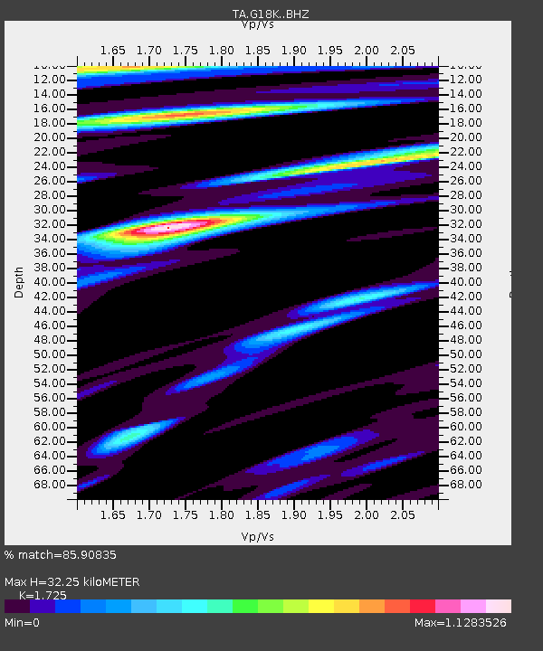
| Estimated Moho Depth: |
32.25 km |
| Estimated Crust Vp/Vs: |
1.73 |
| Assumed Crust Vp: |
6.1 km/s |
| Estimated Crust Vs: |
3.536 km/s |
| Estimated Crust Poisson's Ratio: |
0.25 |
|
| Radial Match: |
85.90835 % |
| Radial Bump: |
400 |
| Transverse Match: |
72.27062 % |
| Transverse Bump: |
328 |
| SOD ConfigId: |
21709731 |
| Insert Time: |
2020-08-13 00:53:44.959 +0000 |
| GWidth: |
2.5 |
| Max Bumps: |
400 |
| Tol: |
0.001 |
|

Signal To Noise
| Channel | StoN | STA | LTA |
| TA:G18K: :BHZ:20200730T00:44:19.649995Z | 1.845466 | 1.4762195E-7 | 7.999169E-8 |
| TA:G18K: :BHN:20200730T00:44:19.649995Z | 0.7360563 | 3.6870563E-8 | 5.009204E-8 |
| TA:G18K: :BHE:20200730T00:44:19.649995Z | 1.16267 | 6.130293E-8 | 5.2725987E-8 |
| Arrivals |
| Ps | 4.0 SECOND |
| PpPs | 14 SECOND |
| PsPs/PpSs | 18 SECOND |


