You are here: Home > Network List > IU - Global Seismograph Network (GSN - IRIS/USGS) Stations List
> Station RSSD Black Hills, South Dakota, USA > Earthquake Result Viewer
RSSD Black Hills, South Dakota, USA - Earthquake Result Viewer
| Earthquake location: |
Komandorskiye Ostrova Region |
| Earthquake latitude/longitude: |
54.6/168.6 |
| Earthquake time(UTC): |
2017/07/17 (198) 11:05:08 GMT |
| Earthquake Depth: |
7.9 km |
| Earthquake Magnitude: |
6.2 Mww |
| Earthquake Catalog/Contributor: |
NEIC PDE/us |
|
| Network: |
IU Global Seismograph Network (GSN - IRIS/USGS) |
| Station: |
RSSD Black Hills, South Dakota, USA |
| Lat/Lon: |
44.12 N/104.04 W |
| Elevation: |
2090 m |
|
| Distance: |
54.3 deg |
| Az: |
62.378 deg |
| Baz: |
314.261 deg |
| Ray Param: |
0.06554698 |
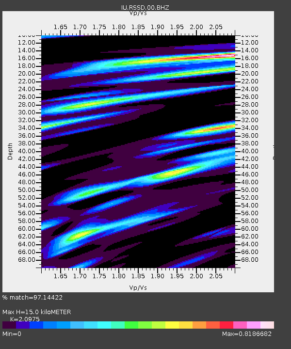
| Estimated Moho Depth: |
15.0 km |
| Estimated Crust Vp/Vs: |
2.10 |
| Assumed Crust Vp: |
6.242 km/s |
| Estimated Crust Vs: |
2.976 km/s |
| Estimated Crust Poisson's Ratio: |
0.35 |
|
| Radial Match: |
97.14422 % |
| Radial Bump: |
248 |
| Transverse Match: |
90.703804 % |
| Transverse Bump: |
400 |
| SOD ConfigId: |
2140511 |
| Insert Time: |
2017-07-31 03:01:01.961 +0000 |
| GWidth: |
2.5 |
| Max Bumps: |
400 |
| Tol: |
0.001 |
|
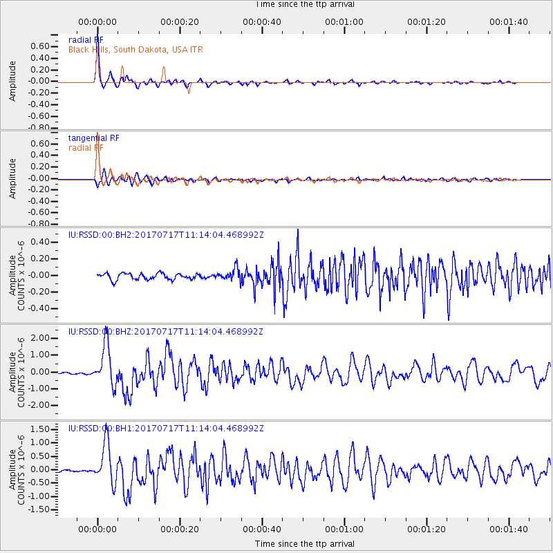
Signal To Noise
| Channel | StoN | STA | LTA |
| IU:RSSD:00:BHZ:20170717T11:14:04.468992Z | 29.923244 | 1.2483134E-6 | 4.1717183E-8 |
| IU:RSSD:00:BH1:20170717T11:14:04.468992Z | 19.020779 | 7.805167E-7 | 4.103495E-8 |
| IU:RSSD:00:BH2:20170717T11:14:04.468992Z | 1.9912729 | 7.455853E-8 | 3.7442646E-8 |
| Arrivals |
| Ps | 2.8 SECOND |
| PpPs | 7.1 SECOND |
| PsPs/PpSs | 9.9 SECOND |


