You are here: Home > Network List > CI - Caltech Regional Seismic Network Stations List
> Station MPP McPhearson Peak > Earthquake Result Viewer
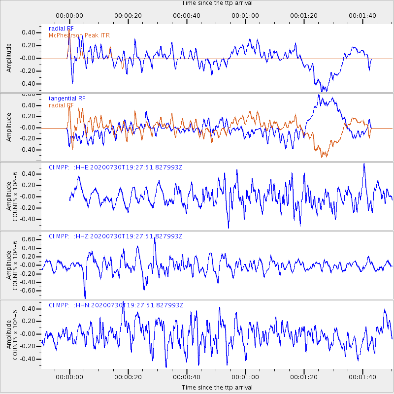
MPP McPhearson Peak - Earthquake Result Viewer
*The percent match for this event was below the threshold and hence no stack was calculated.
| Earthquake location: |
Tonga Islands |
| Earthquake latitude/longitude: |
-18.9/-173.4 |
| Earthquake time(UTC): |
2020/07/30 (212) 19:16:48 GMT |
| Earthquake Depth: |
10 km |
| Earthquake Magnitude: |
5.6 Mww |
| Earthquake Catalog/Contributor: |
NEIC PDE/us |
|
| Network: |
CI Caltech Regional Seismic Network |
| Station: |
MPP McPhearson Peak |
| Lat/Lon: |
34.89 N/119.81 W |
| Elevation: |
1739 m |
|
| Distance: |
73.8 deg |
| Az: |
43.513 deg |
| Baz: |
232.456 deg |
| Ray Param: |
$rayparam |
*The percent match for this event was below the threshold and hence was not used in the summary stack. |
|
| Radial Match: |
48.239075 % |
| Radial Bump: |
400 |
| Transverse Match: |
51.70162 % |
| Transverse Bump: |
400 |
| SOD ConfigId: |
21709731 |
| Insert Time: |
2020-08-13 19:24:31.870 +0000 |
| GWidth: |
2.5 |
| Max Bumps: |
400 |
| Tol: |
0.001 |
|
Signal To Noise
| Channel | StoN | STA | LTA |
| CI:MPP: :HHZ:20200730T19:27:51.827993Z | 0.6118571 | 7.3573155E-8 | 1.2024564E-7 |
| CI:MPP: :HHN:20200730T19:27:51.827993Z | 0.7198285 | 1.1385857E-7 | 1.5817457E-7 |
| CI:MPP: :HHE:20200730T19:27:51.827993Z | 1.077354 | 1.3749384E-7 | 1.2762179E-7 |
| Arrivals |
| Ps | |
| PpPs | |
| PsPs/PpSs | |


