You are here: Home > Network List > NO - Norwegian Seismic Array Network Stations List
> Station SPB1 > Earthquake Result Viewer
SPB1 - Earthquake Result Viewer
| Earthquake location: |
Komandorskiye Ostrova Region |
| Earthquake latitude/longitude: |
54.6/168.6 |
| Earthquake time(UTC): |
2017/07/17 (198) 11:05:08 GMT |
| Earthquake Depth: |
7.9 km |
| Earthquake Magnitude: |
6.2 Mww |
| Earthquake Catalog/Contributor: |
NEIC PDE/us |
|
| Network: |
NO Norwegian Seismic Array Network |
| Station: |
SPB1 |
| Lat/Lon: |
78.18 N/16.39 E |
| Elevation: |
301 m |
|
| Distance: |
46.4 deg |
| Az: |
352.386 deg |
| Baz: |
21.969 deg |
| Ray Param: |
0.07066274 |
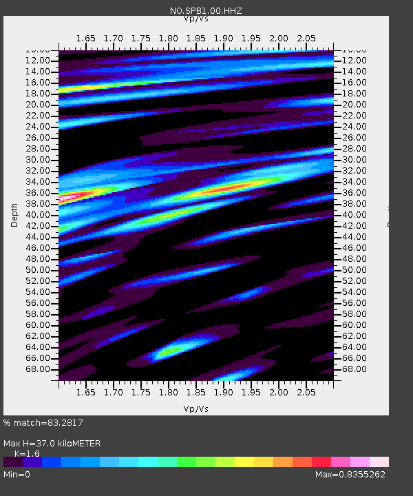
| Estimated Moho Depth: |
37.0 km |
| Estimated Crust Vp/Vs: |
1.60 |
| Assumed Crust Vp: |
6.545 km/s |
| Estimated Crust Vs: |
4.091 km/s |
| Estimated Crust Poisson's Ratio: |
0.18 |
|
| Radial Match: |
83.2817 % |
| Radial Bump: |
400 |
| Transverse Match: |
78.679924 % |
| Transverse Bump: |
400 |
| SOD ConfigId: |
2140511 |
| Insert Time: |
2017-07-31 03:02:27.447 +0000 |
| GWidth: |
2.5 |
| Max Bumps: |
400 |
| Tol: |
0.001 |
|
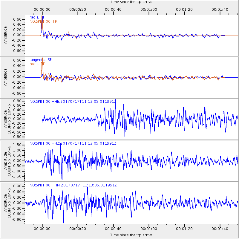
Signal To Noise
| Channel | StoN | STA | LTA |
| NO:SPB1:00:HHZ:20170717T11:13:05.011991Z | 6.232829 | 4.995204E-7 | 8.014345E-8 |
| NO:SPB1:00:HHN:20170717T11:13:05.011991Z | 3.7177892 | 2.6492128E-7 | 7.1257745E-8 |
| NO:SPB1:00:HHE:20170717T11:13:05.011991Z | 2.162258 | 1.478406E-7 | 6.837325E-8 |
| Arrivals |
| Ps | 3.6 SECOND |
| PpPs | 14 SECOND |
| PsPs/PpSs | 17 SECOND |


